June 22: It was another cold morning, but once again I managed to drag myself out of my sleeping bag and got on the trail by 6:30am.
The trail went over a couple of small snow chutes. Strictly speaking, they wouldn't have been difficult to go around, but I was still carrying micro spikes so I went ahead and used them for a traverse which would be faster than going around. And on frozen snow--and the snow was definitely frozen this early in the morning--micro spikes are awesome. That's the kind of terrain they do best in! So I put on the micro spikes and charged across the traverses without worry.

Throughout the day, I relived memories of my Colorado Trail thru-hike. The whole day, I followed terrain that was familiar to me. I remembered the steep, exposed hillsides that I now passed over. When I did the Colorado Trail, I remembered there being a light dusting of snow from the night before along the area. There weren't any snow chutes, but a light dusting covered the entire route. This time, most of the route was snow-free, but there were still snow chutes that needed to be crossed. And, of course, I was hiking in from the opposite direction than I did during my Colorado Trail thru-hike.
I passed the campsite which was among one of my worst nights ever on a trail. The weather, I remembered, was brutal, with strong winds and heavy rains. I was pretty wet all the way through, miserable and cold all night, and had decided if I got so cold that I stopped shivering (a sure sign of life-threatening hypothermia), I'd evacuate to the outhouse a couple of miles away. It never came to that, thank goodness, but it was a bad night. That next morning, however, cleared up and while drying out gear, a moose wandered by my camp. Those were some of my best moose photos I ever got, and it happened right there. I wondered where the moose was now. Was it watching me from the trees?
I stopped to use the pit toilets at the Eddiesville TH, and they still were in good shape. I'd evacuate there in a pinch if I had to, but fortunately, today's weather didn't require anything so extreme. The day's weather was mostly sunny and pleasant. Cold in the morning, but reasonably warm in the afternoon.
I was, however, a bit annoyed to see what good shape the gravel road to the Eddiesville TH was in. Amanda was supposed to fly out to Colorado today to come and meet me. The problem, however, was that we weren't sure where we could meet up. I had talked to the woman at the visitor center in Creede asking about locations where a rental car could drive along the trail and she assured me that this road was only reachable with a high-clearance vehicle. Looking at the road, however, I'm pretty sure that wasn't true. I could have told Amanda to meet me there! But not knowing this earlier and unable to contact her, I pushed onward.

Shortly thereafter, I passed two hikers going in the opposite direction who introduced themselves as Shangry (short for "Short and Angry") and Super Glamp, Colorado Trail thru-hikers that started their journey at the Denver end of the trail. They were the first Colorado Trail thru-hikers I would meet on the trail! I'd certainly see more as the days marched onward. These two were particularly early in the season. They asked about the terrain ahead, but I had to tell them that I really didn't know much since I had only gotten on the Colorado Trail late the day before. The San Juans I had largely missed, but I did tell them the rumors that I had heard: Passable, but with a few sketchy areas. Which sounded a lot like the terrain they had already gone through having started so early in the season. The trail ahead for me, they said, was basically snow-free. By the time I reached the areas where they had a lot of snow, it would likely have melted. The rest of Colorado should be a cinch.
We continued on in our separate directions. I was expecting a couple of fords in the near future. The one crossed a larger river--I remember having to ford it when I hiked the Colorado Trail. The other one was a tributary that I didn't have to ford before, but water levels were much higher this early in the year and I was assured that it would have to be forded by multiple other hikers. (Now that I was on the Colorado Trail, I was passing several people each day.) When I saw the crossing, however, I saw that I could just rock hop across it. It wasn't super easy, but it wasn't too bad either. I'd only have to ford one river after all.
The day's hike was mostly flatish and along good trail the first half of the day, then followed gravel roads the second half of the day. I passed the official 1000-mile mark of the trail (although my exact distance was somewhat less given the alternates I had done).
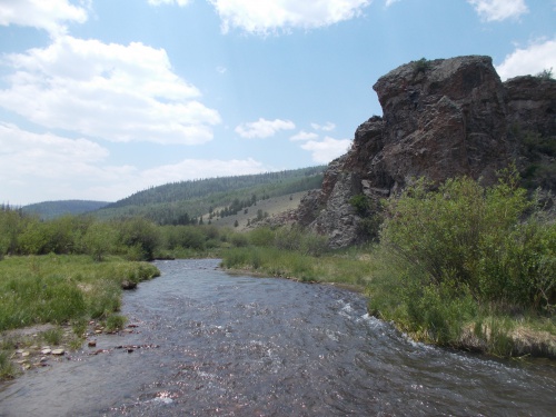 |
| This was the one river I had to ford today. |
So I made excellent time and set new distance and step count records along the way. (About 25.5 miles and 54,525 steps.)
Along the road walk, one vehicle that drove by to stop and ask if I had started in Durango--obviously mistaking me for a Colorado Trail thru-hike hiker.
"No," I told them, "I started at the Mexican border. A bit further away than Durango."
Which about made their eyes pop out. It's always an amusing reaction when someone isn't expecting you to have done such a long distance. =)
Near the end of the day, I ended up along Saguache Park Road, which was another gravel road but well graded and would have been easy for a rental car to drive on. Many of the gravel roads would need a high-clearance vehicle, but this definitely wasn't one of them and I found myself annoyed at the woman at the visitor center who never mentioned this as a possible option to meet up with Amanda either. Nor did I get a signal where I could call Amanda and let her know that she could come out and camp with me on the trail tonight. Actually, because I didn't get a signal, I could only assume she had made it into Colorado fine. For all I knew, her flight had been canceled or delayed or there was some issue that prevented her from visiting. I had no way to check without a cell phone signal. But in theory, if all went well, I knew she was somewhere in Colorado and planning to wait for me at Cottonwood Pass tomorrow.
I found a nice little campsite located a bit off the main road and set up camp for the night. I finished hiking by 6:30 in the afternoon, a solid two hours before sunset which is all the more remarkable considering I set myself new distance records today.
The flies in the campsite turned into an annoyance as sunset approached, but at least they weren't biting. All-in-all, it was a pretty good day on the trail.


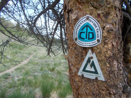 |
| I found the Colorado Trail way markers kind of comforting. Like meeting up with an old friend. =) |

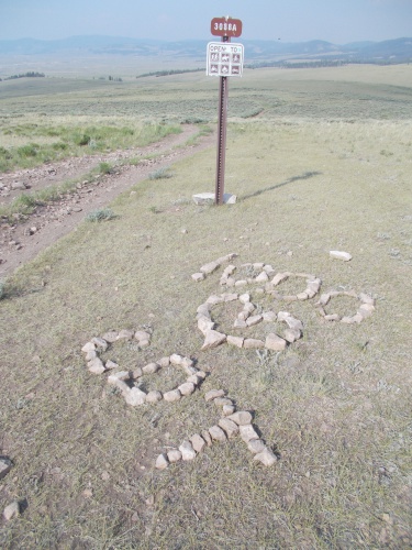 |
| Someone took a bit of time off their hike to arrange these rocks at the 1000-mile marker. |
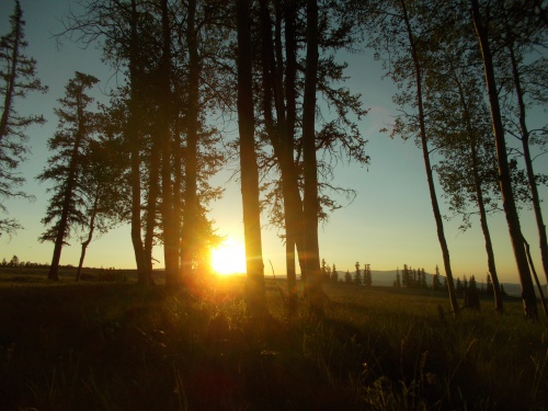 |
| Sunset from camp! |


1 comment:
I doubt the lady at the Creede visitor center had much accurate or timely information about backroads north of town on the other side of the divide. That area is not very local to Creede for people visiting in cars.
Post a Comment