Friday, August 29, 2014

Day 33: Following the Mogollon Rim

May 15: In the morning, I walked into town to mail my laptop ahead to Flagstaff. It was kind of an annoyance since the walk into town and back took the better part of an hour and wasn't contributing to my progress on the trail, but it was either that or carry the darned thing all the way to Flagstaff and that just wasn't going happen!

On the walk back, I called my mom on my cell phone to let her know I'd be leaving town and that my next resupply point was Flagstaff, an estimated 9 days away. Annoyingly, my phone cut off while I was talking to her and it gave me a message saying that the battery had run down. What?! I had the thing plugged in all night! Or at least I thought I did.... And the cord to recharge it was in with the laptop I forwarded since I didn't expect I'd find any electrical outlets on the trail between here and Flagstaff. I couldn't even plug it in just to finish the phone call. Nor use it at all until I reach an electrical outlet in Flagstaff. I was cut off for the next nine days!

Oh, well, nothing I could do about that....

I packed up my backpack and headed out of town.

The Arizona Trail follows the length of the Mogllon Rim for the next 16 miles or so. The Mogollon Rim is a rather impressive geological feature stretching about 200 miles across Arizona and defines the southern edge of the Colorado Plateau. Much of the land to the south of it lies between 4,000 and 5,000 feet above sea level while the land to the north of the escarpment rises to about 8,000 feet above sea level. The long cliffs between the two stretch as far as the eye can see in both directions. And I'd spend the entire day following the trail eastwards near the base of the Mogollon Rim.

The day was warming up and I really wanted to get up and on top of the rim where temperatures would undoubtedly be cooler, but it wasn't meant to be. At least shade was relatively plentiful and the trail largely flat for most of its length. Just coming out of Pine was the steepest section of the trail for the day, and even that wasn't too bad.

Along the way, I saw a number of ribbons attached to branches and rocks along the trail. Most of the time, I just ignore them, but these were so frequent and persistent, I started paying more attention to them and eventually came to the conclusion that they were route markers for a race of some sort. I'd learn later that there's an annual Mogollon Monster 100 race along the trail here, although the race is apparently misnamed (slightly) since the route is actually 106 miles.

The only person I saw the whole day was a lady walking her dog near the trailhead. Beyond that, I was alone on the trail again.

I set up camp at a wooden bench between North Sycamore Creek and Chase Creek--a bench seemed like a more useful feature for camp than something like--you know, water. =) I was originally headed for Chase Creek until the bench pulled me to a stop. Anyhow, there were probably fewer bugs way out here than next to a creek. It was for the best, I told myself!


I really want to know more about this creation. Who created it?
How long did it take them? It's a neat little trick!
Red Rock Spring had plenty of water!
The Mogollon Rim was prominent all day long!

I saw these ribbons all along the trail. A race, perhaps? Yes!
The Mogollon Monster 100!
Webber Creek
This register was located by Webber Creek. The last thru-hiker to sign it was
just 5 days before! I'm catching up on some of them! The only name
I recognized (other than my own) was Whitney Houston who I met barely
60 miles into my hike. He signed the register on May 3--a whopping
12 days before I did. He's moving fast!
Sego lily
Hedgehog cactus
These ribbons were my best clue for figuring out what race went
through here. Mog100--the Mogollon Monster 100!
Mogollon Rim
More Mogollon Rim views.
It seems like water should come out of this, but if it does, I couldn't
make it work. (It did sound like it was trying to pump water and failing when
I turned the knob, though.)
A lot of places along the rim had these hoodoo-like structures
all along its length.
Reflectors on the trail! Probably for those race runners at night.
The Arizona Trail overlaps the Highline Trail along the Mogollon Rim
which is marked with diamonds like this one,
I'm sitting on my bench next to camp. =)

Wednesday, August 27, 2014

Day 32: A day in Pine

Let me take you on a virtual tour through Pine, AZ.
Here's the post office where I picked up my mail drops.
May 14: Really, nothing happened today. I was thinking about continuing onwards, but I started doing some math in my head and realized that at the pace I was going, there was a good chance I might hit the Grand Canyon during Memorial Day weekend. I felt that was a bad idea for a couple of reasons. Not just because it would be crazy busy there at the time--more so than usual, at least--but also because I needed a permit and the competition for them would likely be a lot more fierce. Nothing good would come from arriving at the Grand Canyon during Memorial Day weekend, and the easiest way to avoid that would be to slow down. Take a day off from hiking!

And Pine was a nice place to take a day off. Anyhow, I felt like taking a day off. I hadn't had a day off since the day Amanda and I had visited Tombstone and Bisbee nearly three weeks earlier!

So I took a day off and did nothing. Well, okay, nothing that would push me further down the trail. I caught up on some shows in my Hulu queue, I wrote and mailed postcards, I did some more grocery shopping. And I wandered around town a bit--once in the afternoon and once in the evening. I couldn't stay locked up indoors all day!

But that was it. Nothing really happened.....

Here's the laundromat where I cleaned my clothes.
I did my grocery shopping at the Ponderosa Market. It didn't
have the joys of a full-fledge supermarket, but it was more than
sufficient to resupply my food for the next 9 days on the trail.
When I saw this sign, I thought that maybe Amanda had dropped by for
a surprise visit! But when I went into the store to find her, she
was nowhere to be seen.... False advertising!
Payson is considered a "trail town" in my data book, but the
closest the trail approaches is about 15 miles away--which
wasn't close enough for my purposes. Pine would be sufficient
for resupplying!

Monday, August 25, 2014

Day 31: Pine!

The Arizona Trail followed this dirt road along
these powerlines for several miles.
May 13: During the night, the wind picked up into a ferocious tempo which was more of a nuisance than anything, but it did cause a killer wind chill for any of my body parts left outside of my sleeping bag! By morning, the wind had fallen to a slight breeze again.

I had a relatively quick 10-mile hike into Pine. Along the way, I ran into an older gentleman carrying what looked like an antique gun. He had a dog with him too, and we stopped to chat a bit before I remembered about my strange animal the day before.

"Hey, you're local!" I said. "Maybe you know what I saw!"

So I started to describe it. "At first I thought it looked liked a baby bear..."

He stopped me to focus on the size of the animal and after that was cleared up, I continued, "But then I saw it had a face like a raccoon--"

"A coatimundi! You saw a coatimundi! It had a really long tail, right?"

"Yes! Yes it did!" Awesome! And a little anti-climatic, too. I still didn't know what it was because I don't think the word coatimundi never crossed my ears before.

"I need to write that down--I'll never remember that name."

I pulled out my journal and he told me, "Don't ask me how to spell it because I don't know." I wrote in my journal how he seemed to say the word: cudamunde.

He went on to say that he likes to take his dogs for a walk through the woods most days, and in all his years of hiking, he's only seen coatimundis four times. They're probably as rare as the elusive gila monster if not more so. I, for one, have met quite a number of people who've reported spotting a gila monster on the trail. Not one person has told me they saw a coatimundi--not until I met this fellow and asked about it.

We finally parted ways and I continued onwards to Pine.

The trail crossed Highway 87 a couple of miles south of Pine, but I pushed on another half a mile or so to an official trailhead where I could walk at least part of the way into Pine on a road less busy than Highway 87.


My first stop was THAT Brewery. I happened to know that THAT Brewery also had cabins behind the restaurant that were available for renting overnight and even provided thru-hiker a special deal on them. I just hoped they weren't already full up! They weren't, though, and I had a room for the night.

I didn't stay there long, though. I had more chores to do.

I walked further into town to the post office--I had a couple of mail drops to pick up including my laptop and maps for the next 200 miles of trail. Then I stopped at the laundromat and cleaned my thoroughly stinky clothes. I didn't bother to dry them again--they'd air dry quick enough. Then I stopped at the small general store and acquired food for the next stretch of trail that would take me all the way to Flagstaff.

And only then did I head back to my cabin for the rest of the day, which I mostly spent online catching up with email and checking up on my websites. I did a bit of Google sleuthing on "cudamende" and learned that no such animal existed, but that there was a coatimundi (or a kudamendi depending on which website I found myself) whose photos looked a lot like what I had seen, and their range did include the southern half of Arizona. I was at the very extreme northern edge of their habitat. They were native of South America--which is where I thought they looked like they came from--as well as Central American and southwestern North America. They were also members of the raccoon family, Procyonidea--which I suppose explains their raccoon-like faces.

This hole in the tree kind of looks like an ear, doesn't it? That's the
only reason I even took this photo. =) The forest--it listens to you!
That looks like the Mogollon Rim up ahead!


Highway 87
Highway 87 into Pine. Just on the other side of Pine is the town
of Strawberry. You'll often see both towns mentioned as if it were
a single community of Pine-Strawberry.
The THAT Brewery and Pub also had cabins in back for rent.
My little cabin for the night!

Friday, August 22, 2014

Day 30: What the f*** was that?!

Sunrise! Bright and shiny!
May 12: The day started with a long, steep drop towards the East Verde River. It was uneventful--just dropping for thousands and thousands of feet in elevation during several miles. The lower I descended, the warmer the temperatures became--no surprise there! As the morning wore on, the heat increased. By the time I hit bottom, even though it was still morning, it was getting uncomfortably warm.

The East Verde River was one of the bigger rivers that the Arizona Trail crosses, and it had no footbridge available either. However, I didn't even have to get my feet wet. The river was low enough that I could walk across on small rocks.

Then the trail climbed steeply in a series of "step-like" patterns. It would climb steeply for several hundred feet of vertical elevation gain, up to to a plateau, then go flat for several miles before climbing up the next steep step to the next plateau. It was kind of nice, too, alternating between a serious workout and a relaxing walk.

The color of the ground was something of a novelty as well. It started as "regular" dirt--a dirty white in color, then within about 10 or 15 steps, turned a dramatic red color as I apparently passed through a sedimentary layer. The red layer of dirt also had some freakishly weird-looking rocks with holes that made them resemble red blocks of Swiss cheese. Then the ground would turn white again--just as suddenly as it had turned red. It might stay white for a quarter of a mile, then turn dramatically red again. So far, this was the most fascinating geological discovery of the trail for me. The color changes were just so dramatic!

My one problem navigating these plateaus, however, was that the trail was all but invisible and started intersecting a lot of cow paths. The trail led largely to the north, but the grasslands covered the trail as much as the non-trails, and I spent an inordinate amount of time studying the grass. Did it look slightly more flattened in that direction? Maybe a little bit shinier in the sunlight? That might be the trail... or it might be another cow path. Ultimately, the most reliable method of following the trail became looking for cairns, and sometimes I had to really look for the next cairn. The next one would sometimes be hidden behind a bush or tree and impossible to see until you walked up to it.

I'd reach a cairn, then look towards the north for the next one or a hint of the trail through the grass. If I saw a cairn, I headed immediately for it. If I didn't, I tried to pick out what might be the trail and followed it vaguely north, sweeping my eyes diligently on both sides of the trail looking for the missing cairn. "Ah ha!" I'd shout into the wild. "There you are!" Then veer off to the cairn and begin the search anew.

A great example of "find the next cairn." The cairn here is obvious, but
do you see that one far off in the distance? That next one is actually
visible (not all of them were), and the Arizona Trail runs between the two.
But do you actually see a trail? No--it's just grass! I followed this "trail"
for miles like this--just moving from cairn to cairn.
At one point, while sweeping the sides of the trail intently for the next cairn, I saw something through the corner of my eye. I turned my head and looked directly at it, and my initial reaction was that it looked like a small bear, in the shade, hugging the bottom of tree. The bear was small, though--it had to be a cub. Which begs the question... where was mama bear?

But then I registered its face. It's face looked... wrong. It didn't really look like a bear's face. It's face looked more like a raccoon. A deformed bear? I thought.

As that thought passed through my head, though, I finally noticed its color. My eyes were adjusted to the bright sunlight and everything in the shade just looked dark, but now that I was focused on the shade, the color started to come out and it looked... red. Or maybe orange. An oranish-red. Not unlike the color of a fox. What the hell was this thing?!

You know how sometimes, you might see something you don't recognize. Maybe it's a bird, or a flower, or something. It might be entirely new to you, but you still recognize it as a bird or a flower or whatever the case may be. I stood there looking at this creature thinking.... I don't know what the hell it is! I don't even know what category of animal this is!

And, of course, I thought--I need a photo of this thing! I whipped out my camera and clicked it on, but before it fully powered on and I could get it to zoom into the animal, the creature let go of the tree and started running quickly away followed by a second creature. And I was dumbfounded once again because these things had tails! Not just a little tail, but the tail stretched high in the air and I could have sworn that the tails looked longer than the bodies of these animals. They were ridiculously long! And just then, they looked suspiciously like... monkeys. Moneys running across the ground. Or, more accurately, a bear/raccoon/fox/monkey hybrid running across the ground.


And I didn't have even one photo to show for it. What the hell did I just see? It seemed like something you might find deep in the South American jungle, but we were a hell of a long away away from any jungles and even further away from South America.

I sat down and immediately wrote down everything I could remember. I wanted to figure out what the heck this was when I got into town. I described it in detail, exactly how I remembered it. Thinking it was a baby bear, then noticing the raccoon face, then the redish-orange color of its fur, and finally it's exceedingly long tail in the air when two of them ran off. I even described in my journal exactly where I saw it, hugging the base of a small tree, and the fact that it ran across the ground away from me instead of climbing the tree. Maybe that would be important to know.

I pulled out my maps and tried to estimate as closely as I could exactly where I spotted the creature--it was definitely after Whiterock Spring at mile marker 445.0 (which I had already passed), but before MM 448.0 (where there was a water drainage dip on the plateau). Probably close to MM 447--closer to the dip than the spring. I used my topo map to find the coordinates of that location: 34.298 north and 111.525 west. Accurate down to three decimal places. Not bad for someone without a GPS. (Admittedly, the last decimal could be off plus or minus two. Those first two decimals are solid, though!)

And I even wrote down the time I saw them: 12:05 PM.

I wrote down every tiny detail I could think of--I was going to figure out what the heck that animal was if it was the last thing I ever did, and I figured it was better to have too much information about the sighting than not enough.

But it would have to wait until another day because for the time being, I was in the middle of nowhere. I couldn't log into Google to do a search. I couldn't call someone up who might know what this strange beast was. I was on my own and the only thing I could do at this point was keep hiking forward.

Look! It's a hiker! Okay, I'll fess up. It's me, taken with the 10-second timer
on my camera after I attached my camera to a bush. =)

Late in the afternoon, the only other strange experience happened while I was walking over one of the plateaus. The air was deathly still, then suddenly I was hit with a blast of wind on my right. Completely out of the blue. It took me by surprise, but it only lasted a few seconds before I was hit by another blast of wind, but this time from the left. That too only lasted a few seconds, then the wind stopped completely.

It was an eerie sensation--I'd never felt anything like that before. I felt pretty confident guessing what it was, though. I'd been seeing dust devils all throughout the day--I suspected I'd just been hit by a dust devil that didn't actually have any dust in it. The circular column of wind must have been rotating clockwise when it hit me from the right. After my body passed halfway through the column and the backside of the wind storm hit me, it changed to the left. Then it passed by me completely leaving the air calm again. It was a perfect explanation, but a wildly eerie sensation when you couldn't even see the miniature column of wind that hit you.

It was a day of strange sightings and experiences--that's for certain. And I didn't see a single person the entire day to tell my new stories to.

I set up camp for the night about 10 miles outside of the town of Pine. I didn't want to get into Pine too early in the morning--not before stuff had opened, at least--so I stopped relatively early in the afternoon to lengthen my walk into town the next day.


Each side of the East Verde River had mileage listed to the end of the trail
in that direction. 440 miles down, and just 360 to go!
The East Verde River wasn't a difficult water crossing!
Prickly Pear bloom
Nearing the top of the next plateau.

Whiterock Spring was dry!
However, that didn't stop these bees from swarming a small seep nearby!
I don't think I exaggerate when I say that I risked my life to get this photo....
(Okay, I might exaggerate a little, but if they all attacked... that might have been bad!)

Prickly poppy
The rocks that looked like Swiss cheese. (The red in the dirt and rocks
doesn't really show up particularly well in my photo--it seemed a lot redder
in person!)

Hedgehog cactus
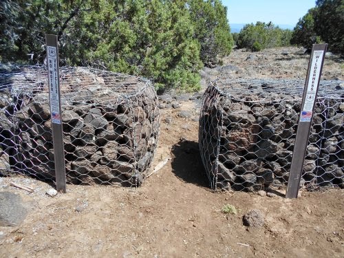
These barriers helped prevent ATVs from entering a wilderness area
where they aren't allowed. These barriers mark the wilderness boundary.
A stock tank on the trail--not a particularly good-looking one either!
This photo really needs a funny caption. Any suggestions?
"I'm falling for you!"

I stopped early in the afternoon after a mere 19.2 miles of walking so I wouldn't
get too close to Pine. I didn't want to walk into town until everything in
town would be open for business. But there was no shade anywhere and it was
hot out, so I rested under the shade of my umbrella. =)
And just look at that beard growing in!
Once the sun got low enough in the sky, a nearby bush was able to cast a
long enough shadow to finally put me in shade without the umbrella.