Friday, July 30, 2010

Getting off the trail, the hard way

June 9: Today I had a short little hike to Walker Pass, where Amanda was scheduled to pick me up later in the afternoon. Due to my diligent hiking, I was going to arrive several hours before Amanda would arrive to pick me up, however, and I didn't feel like sitting on the side of the road killing time. I'd hitch down to Lake Isabella and wait for her there, I thought.

That was my plan. It seemed like a simple plan, but I managed to royally screw it up. It started with my arrival at Walker Pass, at about the same time Morph and Moonshadow arrived. They too planned to get off at Walker Pass in order to backtrack to do the section between Idyllwild and Big Bear that they had skipped due to fears of snow. So the three of us were at Walker Pass, trying to hitch a ride into Lake Isabella about 35 miles away.

I was able to check my e-mail on my Peek device from the pass, so I did, getting a couple of e-mails from Amanda letting me know that Gwen, a friend from letterboxing, would be in Kernville and that we could stay at her place, and that if I get in early, to give her a call to pick me up from Walker Pass. Awesome! I wouldn't have to depend on hitching a ride!

I tried my cell phone, but alas, got no service. *grumbling* Here I was, with a ride set to pick me up, and no way to contact her. I thought about e-mailing Amanda to call her for me, but Amanda was already flying. She couldn't get e-mail. I could only communicate via e-mail, and Amanda could only communicate via cell phones. We couldn't communicate. Gwen, I //could// e-mail, but I know she doesn't get online very often, and she likely wouldn't get the message for who knows how long.

So while Morph and Moonshadow took turns trying to hitch a ride, I sat there reading the rest of my e-mail and scratching my head about how to let Gwen know that I was there.

A car pulled over, but it wasn't clear if the driver was stopping, or planning to offer us a ride. He got out with his dog, telling us that he was taking his dog to the lake to swim, asking us where we were hitching from. "Right here," we told him. "To Lake Isabella." Right where he was going. He was an elderly gentleman, and the knives in his head seemed a bit rusty. At first he said he'd never heard of the Pacific Crest Trail, then later that he had friends who hiked it. He chatted with us for five minutes or so, then wished us good luck on our journey, and left us there.

Moonshadow said, "You know, I think he forgot we were trying to get a ride."

Morph made a comment about, "It was just as well. We probably would have died if we got a ride from him."

Then I had a lightbulb go off in my head about how to let Gwen know I was at Walker Pass. I e-mailed wassamatta_u, a man who is always online--or at least seemingly so--and asked him to phone Gwen for me.

Just as I finished punching in the e-mail, a vehicle pulled over without any of us even sticking out our thumbs. "You need a ride into town?" the lady asked. Well sure.....!

The lady was Okie Girl, a trail angel who was actually heading to the nearby campground with ice cream, drinks, and all sorts of other snacks for thru-hikers stopping by. Morph and I piled into the back of the truck and Moonshadow got in front, and I whipped out my Peek to send wassamatta_u another e-mail that essentially read, "Abort! Abort! Abort!" I didn't want Gwen driving up to find me if I wasn't going to be at Walker Pass.

As soon as the truck started going down the road, however, I lost my fragile e-mail connection. Wassa didn't get my abort message. Shoot. I wasn't sure what to do now. Either my cell phone nor e-mail worked. Shoot, shoot, shoot.

We dropped off the food and drinks at the campground, then continued toward Lake Isabella. I kept both my e-mail device and cell phone out, hoping to get something one of them to get the abort out, but they both stayed stubbornly without a signal. Our ride stopped once again in Onyx so a hiker could pick up their maildrop there, but again, no signal.

Finally, we arrived in Lake Isabella, and at long last, my e-mail connection once again started. My abort finally went out, but I feared it was too late. Then I got a message from wassa saying he contacted Gwen and she was on her way. Drats! It was too late! Now I'm in Lake Isabella, and nobody knew it.

Morph and Moonshadow checked into a motel, then we got a ride from the trail angel to the Pizza Factory near Vons. The other hikers getting rides wanted to resupply in Vons, so it was a convenient place to part ways. Okie Girl allowed me to use her cell phone (which actually worked!) to call both Amanda and Gwen, to let them both know that I was at the Pizza Factory in Lake Isabella, in the Vons shopping center complex. I also e-mailed wassamatta_u to let him know what I mess that I made of things, but that I'd get things sorted out eventually, and that both Gwen and Amanda now have a message about my location, though who knows when either of them would get it.

I'd wait at the Pizza Factory all day if I had to, though. I was in it for the long haul. I wasn't moving. =) At least I wouldn't go hungry or thirsty, I was inside where it was cool, and I had restrooms readily available. It was a good place to wait.

The pizza came, and while eating and talking, I heard my name in the background. Huh? I looked up, and a girl behind the counter was asking if there was a Ryan in the store. Me? I waved, tentatively. "I'm Ryan."

"There's a Gwen on the phone," she told me.

Ah, yes, that's definitely for me! Gwen told me that she just got my message, after my sadly sending her on a wild goose chase looking for me on Walker Pass. But it wasn't a totally wasted trip. She was able to pick up two hikers trying to hitch a ride up to Walker Pass, and met a few other hikers at the campground that told her I had gone into town. Gwen said she'd be there in about 20 minutes to pick me up. Awesome!

I also asked if she could call Amanda to leave her a message letting her know that I'd be with her in Kernville.

Finally, the mess was getting sorted out. And I was full on pizza. Life was good. =)

Gwen arrived, and gave Morph and Moonshadow a ride back to their hotel room. It was only a half mile or so away, but they originally expected to walk back, so they were happy to get a ride back instead. Gwen also gave them her contact information so when they get back to the area, she could give them a ride back to Walker Pass. They made out pretty well in the deal. =)

Then Gwen drove me to Kernville, then Amanda arrived a few hours later, and all was right with the world once again. I got on the computer and started typing up more than two weeks of adventures I'd fallen behind in, until I crashed, too tired to stay up past hiker midnight (sunset).


In August, I'll be participating with Amanda in the Washington Trail Association's Hike-a-Thon. If you haven't already, please consider sponsoring us. (Especially me!) The folks do great work helping to fix up and maintain trails such as the Pacific Crest Trail and help make thru-hikes such as mine possible. If you enjoy reading this blog, consider giving something back to the trails that make it possible. Thanks!

Wednesday, July 28, 2010

Water! Water! My Kingdom for a Drop of Water!

June 8: I woke up earlier than ever, hitting the trail before the brutal sun baked me. Despite my early start, Morph and Moonshadow passed me in camp. They must not have camped very far back, I thought, and wow, what early morning risers!

After eating breakfast and packing up camp, I checked my water supply. About 1 1/2 liters. Not much, and I'd probably need to cover 12 miles to fill up. It wasn't an ideal situation. I needed an early start, and needed to get to that water source before the day heated up too bad. Heaven forbid, I just couldn't wait out another long lunch break, and I couldn't go that far in the middle of the day.

So I tore up the trail, quickly passing both Morph and Moonshadow, finally catching up with Graduate at the water cache. I could see Graduate shaking the milk containers, frowning. It didn't look good.

"So what's the verdict?" I asked.

"It's dry. Nitro was right." Drats. I signed the logbook, something about not being a desert tortoise and that I actually needed water, and rested for a few minutes. But I didn't rest long. I couldn't afford to. I didn't have enough water to rest. I checked what was left. A little less than a liter, by the looks of it, with seven miles and over a 2000-ft mountain before the next spring. It was time to start rationing water.

I had been conservative in my drinking of water already, but I took it to a new level, this time telling myself that I would not be allowed to take more than one gulp of water from my Platypus every 15 minutes. I could still reach the spring, but I'd arrive very, very thirsty.

I started climbing up the mountain. A great deal of the trail was still in the shade. The slope was steep enough, and the trail followed the west side of it for much of the distance, so the mountain itself created its own shade. At least as long as the sun was still fairly low in the sky. The longer I waited, the less shaded the trail would be. If I had to hike uphill for several miles, I wanted to do it in the shade, and in the cool of the morning. So I pushed on, not taking any breaks.

When I started getting thirsty, I'd pull out my watch to look if 15 minutes had elapsed. Five minutes?! $#!^! The thirst started growing, and I looked again. It seemed like an eternity, but finally fifteen minutes elapsed, and I sucked in a mouthful of water. Most of it I drank immediately, but I left a small bit in my mouth, which I pushed around with my tongue, enjoying the sensation of water in my mouth. Then the water started getting warm, so I gulped the rest and the hike continued.

After a couple of miles, I started approaching what looked like a top to the mountain. I had my doubts, though. I'm quite familiar with false summits, and it didn't feel like I had climbed enough in elevation to have already made it to the top. I hoped I was wrong and it really was the summit, but a nagging voice in my head told me not to get my hopes up. It was probably a false summit.

And it was. I went up the saddle, and saw a chain of ever higher mountain tops stretching out. Crap. I broke my water rationing rule and took a swig of water anyhow at this point. While I was not yet at the top, the trail looked much less steep at this point. It shouldn't be quite so hard to go up as before. So I hoped.

I pushed on, as the morning grew warmer and warmer, but largely kept to my one gulp of water every 15 minutes regimen.

I finally made it over the peak, took another celebratory swig of water, and started the long, slow drop down the other side of the mountain. There was a lot more sun now, and the temperature grew increasingly warm, but at least I was now heading downhill and making better time than ever.

Graduate caught up with me at the turnoff for the Yellow Jacket Spring, and we started the steep 0.6 mile off-trail hike to the water supply. Once I reached the turnoff and knew the spring was just 0.6 miles away, I ended my self-imposed water restriction and started sucking down the water a lot faster.

On the way down, we spotted Sticky Fingers, climbing back up to the trail, who was also quite annoyed about the off-trail hunt for water.

She also told me that she was finally able to use her cell phone and figured out what was going on in the outside world. She had told me the previous day that she got a message from Warner Springs Monty asking if she was okay and to check in. She was hoping to get a ride from him from Walker Pass to Mojave where she was going to meet her husband, but that there was something strange about the message. He'd try calling a couple of times, and I joked that he must be stalking her.

She was finally able to use her phone and finally got the full story. Someone had gone to the Andersons looking for her, a suspicious character, and word went out to warn Sticky Fingers about the shady character. But then nobody was able to contact her (she was off hiking, in the wilderness, where cell phones didn't work), and then friends started to worry about her safety. Was she okay? The hunt for Sticky Fingers was on, and messages streamed around the Internet trying to find her whereabout.

"Too bad they didn't contact me," I said. "I could have told them you were with me." Some people might even consider me a shady character. =)

She said she was a little embarrassed about all the fuss made over her, while she's hiking completely unaware about the frantic search going on for her. But she assured everyone that was okay, and the hunt was finally called off.

Sticky Fingers continued on--she was trying to get off of Walker Pass that afternoon--and Graduate and I hiked down to the spring. Actually, calling it a spring is a rather generous. It's actually a seep, a wet patch of ground that mostly requires digging a hole to collect any water from. Sticky Fingers and the water report said if we walked down it far enough, there is a small trickle of water that doesn't require digging a hole to get to, however, so Graduate and I went in search of it.

It was only a trickle, but I never felt so happy to see such a lame water source in my life. I finished drinking the last of my water, then filled up a one-liter bottle with water. When I looked in it, it was a solid brown color. Bleh! I poured out the water and tried again, this time using a cloth to pre-filter the water first. The water looked a lot better this time, and I drank the whole thing within minutes without any further treatment. It was only a little after 10:00 in the morning, but it was time for a lunch break. The next water source was a long way off, and I needed to rehydrate anyhow. I wanted to stay near the water for hours and hours, resting in the shade. So that's what I did.

About a half hour later, I heard some people talking upstream. Probably Morph and Moonshadow, since I knew they were immediately behind us, and I shouted down for them to keep going--there was free-flowing water nearby, and those two joined our water club as well.

I waited for a good four hours, drinking three liters of water before hitting the trail again. It was the first time I had a chance to chat with Moonshadow on this hike, and it was nice catching up to her since I remembered her from our 2003 Appalachian Trail hike. Morph also hiked with us in 2003, but I had seen him several times starting in Idyllwild. Moonshadow I kept seeming to miss all the time. A bit later, another hiker I'd never met before named Danny caught up with us around the spring.

All all eventually headed back up to the trail. We all swore that the spring seemed like it was 1 1/2 miles off the trail, not a mere 0.6 miles, so Morph checked the distance on his GPS and I timed my walk to calculate the distance, and we all concluded that yes, it really was only 0.6 miles off the trail. It seemed a lot longer than that on the way down, but then we were all severely dehydrated at that point which probably affected our sense of distance.

I hiked another seven or eight miles to a shelter--one of the few shelters along the PCT--for the night. It was a wonderful, fast-flowing spring, a nice stop for the end of a 20-mile day. I didn't stay in the shelter, electing to cowboy camp outside where the air seemed less stagnant. Another day, another adventure.


In August, I'll be participating with Amanda in the Washington Trail Association's Hike-a-Thon. If you haven't already, please consider sponsoring us. (Especially me!) The folks do great work helping to fix up and maintain trails such as the Pacific Crest Trail and help make thru-hikes such as mine possible. If you enjoy reading this blog, consider giving something back to the trails that make it possible. Thanks!

Monday, July 26, 2010

A Lonely Day on the Trail

June 7: Sticky Fingers and I were on the trail hiking by 5:30 in the morning. It was already surprisingly warm for how early in the morning it was, and we wanted to hike while it was still cool. Well, I did, at least. Sticky Fingers was putting on big miles to get off at Walker Pass to meet her husband, and needed to pull off some big days. Me, I'm just lazy. I don't want to hike in the hottest part of the day.

By 8:00 in the morning, I was sweating bullets. It was hot! I felt like taking a lunch break already, but I refrained. If it felt this bad at eight in the morning, the noon day sun was going to be even worse. No, now was still the time to be hiking. But damn, it was hot!

Sticky Fingers and I largely hiked at our own pace, crossing paths multiple times throughout the morning. The trail followed a creek for a few miles, and water was plentiful along this section. By late morning, however, we passed the last of the water sources. The next surface water close to the trail would be over 30 miles away, but there were a couple of water caches on the trail. Hopefully, knock on wood, they still had water.

I reached the first water cache shortly after Sticky Fingers, but most of the bottles I saw looked empty. "Anything left," I asked.

There were a few gallons of water left, and I help Sticky Fingers hold her water bottle steady as she poured water into them, then she did the same for me. Between the two of us, we finished off about half the water that was left in the containers. Sticky Fingers, who'd been hiking a lot faster than me, had filled me in on all the hikers she passed, and from the sounds of it, there was a significant group not more than about five or ten miles behind us. Some of them, clearly, would not be getting water from the cache.

I was thankful I got to the water cache before it ran dry. It was almost certainly going to be dry by noon.

Sticky Fingers and I stopped in the shade of a Joshua tree for a half hour or so, preparing mentally for the next stretch of shadeless and waterless trail. My topo map showed a bit of green about five miles up the trail, but it looked pretty desolate until then. It was a bit late to hike five miles for a possible shady spot in the trail, but it also seemed a little too early to quit for lunch as well. So on I went, figuring to hit the shade sometime after 1:00 in the afternoon. It was going to be hot.

And it was hot. The air was stale and stiff. Heat rose off from the rocks and even the cactus. The trail climbed upwards, but it the gain in elevation didn't help cool the air. It wasn't enough. Not even close. But it was still up a slope steep enough to make walking a real effort, putting one leg in front of the other.

From a distance, I could see the green splotch on my topo map. Trees. There would be shade there. Somewhere. I just had to reach it. And on I pushed.

I saw a tree on the side of the trail. The hillside was steep, but the trail itself had been flattened a bit, and I thought, "That tree. That tree is where I want to stop." I could only see the top of it from my angle, but it looked large enough to provide a good amount of side. There might not be anywhere to sit under the tree, but it was adjacent to the trail, and I could sit on the trail if I had to.

As I got closer, more of the tree came into view, then I found Sticky Fingers sitting at the base of it as well. She must have had the same thought I did  upon seeing this tree. It was The Tree. The Tree of Life. The Tree of Shade.

I stopped, and we rested and ate for an hour or so, before he got up to push on. She needed to do big miles to meet her husband. Me, I needed to do little miles. Slow down, to meet Amanda. So I laid out on the trail and read my magazine. Then I napped.

The sun moved, and twice I had to pick up my stuff and move six feet more down the trail to where the shade had moved, but I had no desire to walk back into the heat. This green oasis was small, and there would be no more shade for miles ahead.

Nearly four hours went by, and I was kind of surprised nobody from the back of people behind me had caught up by now. I expected someone to have reached me by now, but Sticky Fingers was the only person I'd seen all day. Then I heard a voice, behind me. "Hey."

I was a little surprised. I hadn't expected to see anyone hiking southbound. I can't remember the last person I saw hiking southbound on the trail. I expected anyone who found me on the trail to be hiking northbound. I looked at the 'intruder.' It was a young girl, who looked vaguely familiar, but I couldn't really figure out why.

"Sorry about blocking the trail," I apologized, trying to move over a little bit to allow her to pass. I really had set up my lunch camp directly on the trail. She got around me, and I introduced myself as Green Tortuga, and she introduced herself as Nitro.

Ah-ha! That's how I know her! She had a PCTA hat on. "The same Nitro that works for the PCTA?" I had seen her give a little spiel about the water and snow report at the kickoff. Yep, that was her.

She seemed a little tired from hiking, and sat down on the trail in the shade and talked with me for about a half hour. I asked about the water cache ahead--I really didn't want to hike off the trail to fill up with water, and I knew there was a water cache ahead, but I didn't know if there was still water in it. Nitro reported that there was some left when she was there, but not much, and she passed eight people going in the other direction, so it was probably empty by now. Drats. I pretty much told her the same thing about the water cache she was approaching.

Nitro was on a five-day backpacking trip, a trip she's required to do by the PCTA each year. I wish all employers required their employees to go on five-day backpacking trips each year! So she was just hiking a small section, noting places that needed trail maintenance along the way.

Eventually she continued on her way, and I continued to sit in the trail, waiting for the heat to subside. Did I mention that it was hot outside? By around 5:30, I was finally tired of sitting, and the heat had actually subsided quite a bit. Time to push on.... After stopping for more than four hours.

Good times!

The news that there was almost certainly no water at the water cache was enormously disappointing to me, and it also meant that I now could not waste so much as a drop of water in my possession. The next available water source was a spring seven miles past the water cache, which itself was 0.6 miles off from the trail. Over a really big mountain. Frankly, I only had enough water to get me to the cache. I knew I could make it to the next source if I had to, but I'd be thirsty when I arrived. And now that I knew the water cache could not be counted on, every drop mattered even more than before.

I stopped for the night about five miles later, having done 20 miles that day, but still five-or-so miles short of the water cache, and twelve-or-so miles short of the next reliable water source. With only about two liters of water left. Grrr....

I didn't have enough water to cook dinner, so I ate snacks. Then I didn't have enough water to brush my teeth, so I didn't. A short while after I stopped for the night, Graduate arrived. Finally! Someone had caught up to me on the trail! I didn't do a lot of miles, but it was apparently enough to keep ahead of everyone else.

And that was it for the day. I assumed Sticky Fingers probably stopped at the water cache, and was probably disappointed to find it empty of water. I expected that there were a number of people not far behind me, and Graduate told me that he thought Morph and Moonshadow might make it into camp there that night, but they didn't.

The wind was picking up again, so I set up camp behind a Joshua tree as a partial wind break. It wasn't especially good, but it was better than nothing, which is what Graduate had. I hoped a strong wind gust wouldn't blow an arm of the Joshua tree off onto my sleeping body during the night, but I was willing to take the risk. (I'm happy to report, none of it fell off onto me.)


In August, I'll be participating with Amanda in the Washington Trail Association's Hike-a-Thon. If you haven't already, please consider sponsoring us. (Especially me!) The folks do great work helping to fix up and maintain trails such as the Pacific Crest Trail and help make thru-hikes such as mine possible. If you enjoy reading this blog, consider giving something back to the trails that make it possible. Thanks!

Saturday, July 24, 2010

A Celebrity on the Trail!

June 5: I hiked most of the afternoon without seeing anyone. Captain Bivy is older and retired and hikes slow, while Biscuit was still sleeping in camp when I left in the morning. I had to push at least 18.8 miles today to the next water source. Water was scarce on this section of trail, and 18.8 miles through hot temperatures was no easy feat. I filled up with five liters of water and headed out.

Not much to report about the trail itself. It finally started getting away from the windmills that seemed to follow the trail for the last several days. Shade became a bit more common as the trail wound through groves of trees, and I even spotted two deer. I've seen a lot of deer over the years, but remarkably few so far along the PCT. In fact, this was only the second and third deer I've seen on my whole hike.

Once again, I stopped for a long lunch break to beat the heat of the noon-time temperatures, this time stopping five minutes before noon under a shady tree at the top of a hill providing a slight breeze. It was a wonderful location, and I ate lunch, read a magazine, and napped. A little after 2:30, Sticky Fingers caught up with me on the trail, and she sat down to rest and chat awhile. She, I learned, had camped at a "big tree" further back on the trail and had already done a good ten miles more than I had that day. Well, aren't I lazy!

I've crossed paths with Sticky Fingers several times over the past few weeks. The first time I met her was just before Big Bear, at the food cache that included the couch on the side of the trail, but she was hiking with a larger group and I don't think we said anything more beyond introductions.

Then we shared a tent at the Saufleys in Agua Dulce, where we talked a bit longer, but not more than about fifteen minutes or so about food and other trail topics of little interest.

The third time I met her was in Mojave, when she talked with Tradja, Jess, Go-Go, and myself for a short time.

About the only thing I learned about her was that she was called Sticky Fingers because she always had her hand in a bag of snacks which made her fingers sticky. (Originally, I assumed it must have been because she was caught stealing something!)

All together, I don't think I spent more than a half hour talking to Sticky Fingers, so I didn't really know much of anything about her, and I still didn't. But she has a way about her, that makes you feel like slowing down and talking to her. Like she's interested in everything and everyone around her, and is very gregarious. A lot of hikers, myself included, are generally quiet introverts, but she'll draw you out to talk. Friendly and curious. Though often times, she's hiking so fast, you don't actually get much time to talk with her.

We talked for about a half hour sitting at the top of the hill, which was nice, but again, we really didn't talk about anything particularly interesting, and at 3:00, I finally put on my shoes ready to hit the trail again. I planned to stop for three hours, until 3:00, and it was time to start hiking again. Sticky Fingers put on her shoes and started hiking as well, but I hiked considerably faster than she did. Perhaps the fact that I was three hours rested and had ten miles fewer miles on my shoes that day was part of the fact, but no big deal. Everyone hikes their own hike, right?

I reached the turnoff for the next water source, a spring about 100 yards off the trail. I stopped to check my water level. The next water source was a creek, just 2.2 miles ahead, so I didn't really need much for that next source, and after checking the water I had, I felt it was enough to get me to the creek. No need to hike 100 yards off trail to get to the spring. But I also looked at the time, and noticed that at the rate I was going, I'd reach the creek--my intended destination for the night--by 5:30 that afternoon. Twenty miles, a three hour lunch break, and I'd still get into camp way too early.

I sat down. Maybe I should walk further? But no, I was planning to meet Amanda at Walker Pass in a few days. I can't get there too early. I couldn't be putting on big miles. I was already hiking much too fast. So I sat down and rested a bit, even though I didn't really need it.

Sticky Fingers caught up with me again, and she checked her water levels, and had way too much water. She took out her pot and started cooking dinner, hungry after hiking nearly 30 miles already that day. (Overachiever!) So we started talking some more, and I found out a lot of very interesting stuff about Sticky Fingers.

In certain circles, she's quite the celebrity. In particular, she's made quite a name for herself among those obsessed with the Titanic. She wrote a little book about the sinking of the Titanic, called What Really Sank the Titanic. I haven't read the book, but in a nutshell, she explained how she studied the rivets, what they were constructed of and how they were installed, and concluded that the Titanic sank so quickly, at least in part, because of the design and installation of the rivets. The New York Times ran a front page article about this latest forensic report about the sinking of the Titanic, which even landed her a guest appearance on the Colbert Report, saying that that was the hardest interview she's ever done. (Amanda and I watched her segment online, and Amanda's response was that he was tough on her. Said if it was her, she'd have been in tears saying, "I just want to talk about the rivets....") After that appearance, her name wound up in the IMDb and Wikipedia. Okay, I looked those up, and there's not a lot of information there, but it does make her a minor celebrity, at least in certain circles. I've never made it into either of those sources!

"There's not even a picture of me on my wikipedia page," she told me.

"Well," I said, as I took a photo of her, "I could change that...."

"Oh, God! No! Not like this!" =)

I don't know what she's worried about. Frankly, she's a very nice looking woman. She might have a thru-hiker smell on her, but that type of thing doesn't show through in an image.

Rivets seem to fascinate her, and she asked me if I had walked on the tube that makes up the aqueduct, apparently riveted by the rivets holding it together. She's probably the only person I've met who'd ever be interested in those rivets on the aqueduct. I just found them annoying to walk on, but didn't think much more beyond that.

So she told me about her experiences doing those sorts of things, and she's really quite a fascinating woman. She's not thru-hiking all the way to Canada--she still has a day job and is only section hiking the trail this year (a very large section, but still, only a section), and I said it was kind of annoying having to worry about paying quarterly estimated tax payments from the trail (something I have to worry about because of Atlas Quest), and she blinked.

"I forgot about that. Argh! I need to call my accountant!"

Well, not the end of the world. If she files it late, it's nothing that a little extra money to the IRS won't fix.

She finished eating dinner, and we walked an additional 2.2 miles to Cottonwood Creek where we set up camp for the night and continued talking about our lives. At the end of the night, I told her the story of Sam McGee and Casey at the Bat. The Casey at the Bat got a gasp from her at the end--I hadn't realized it, but she swears she had never heard that poem before and didn't expect Casey to strike out. She gasped when I finished, "...for mighty Casey has struck out."

"What, you seem surprised?"

"Poor Casey! I was surprised!"

Which amused me to no end. How could a red-blooded American have grown up without ever hearing the story of Casey at the bat?

"Well, don't worry. Casey had it coming. He was arrogant, and stupid. He got what he deserved." =)

It started getting dark, and Sticky Fingers went to sleep. I pulled out my Peek device and e-mailed Amanda: "Find book called What Really Sank the Titanic. Must read!" Actually, I didn't do that, because my Peek device didn't get service, but I wrote a note about it in my journal so I could try finding it later myself. =)

Sorry, Sticky Fingers. You'll need a new trail name now if you want to hike incognito next time around. ;o)


In August, I'll be participating with Amanda in the Washington Trail Association's Hike-a-Thon. If you haven't already, please consider sponsoring us. (Especially me!) The folks do great work helping to fix up and maintain trails such as the Pacific Crest Trail and help make thru-hikes such as mine possible. If you enjoy reading this blog, consider giving something back to the trails that make it possible. Thanks!

Thursday, July 22, 2010

Goodbye, Southern California!

June 5: I went down to the lobby for the continental breakfast provided by the hotel and found several hikers already there, including Charmin, Double D, Fuck Cancer, and Graduate. They were already out planning their afternoon, and mom offered them all rides to the post office and to Albertsons while I went back to pack up my bag. They all were planning to zero in Tehachapi, but I was preparing to hit the trail again--a long, waterless stretch on increasingly hotter weather.

Charmin dropped by the room to chat a bit, or so I thought, until she asked if she could use the computer. Ah-ha! The truth comes out! =) I hadn't even thought to offer the use of the computer, selfish pig that I am, but had not problem with setting it up for her then I went back to packing my stuff for the day's hike.

By around 11:00, Mom finally dropped me off at the trailhead on Highway 58, and I started hiking. I had no idea who was ahead of me. Or even if anyone was ahead of me. Everyone I knew about was either in Mojave or Tehachapi taking a day off. But I had miles to do.... and I was now doing them in Central California.

My first guidebook ended at Highway 58, and I started using my new Central California PCT guidebook. I waved goodbye to Southern California and looked, with a bit of trepidation ahead, to Central California and the High Sierras. I wasn't in the High Sierras--not yet--but there were some scary-looking elevation charts for this section of trail coming up.

I only went a mile or so before bumping into Dude and Trouble. I'd never met either of them before, but I recognized their trail names from Mr. Mountain Goat's blog, so we mostly talked about him. I was kind of surprised to see Dude and Trouble, though, since the last blog entry I had read suggested that he thought these two were ahead of him. And I knew Mr. Mountain Goat was well ahead of me. What were they doing back here on the trail? It seems Dude got sick and took a lot longer to recuperate than Goat expected. He was probably hiking his legs off trying to catch up with these two, not realizing that they were actually behind him.

Trail communication is actually remarkably pretty good, but sometimes it fails, and this is one of those instances where it failed. Oh, well, at least this isn't my problem to worry about. =)

The trail climbed steadily higher and higher, and there's not much to report about this section except a severe lack of water. The next known water source was 16.6 miles from Highway 58, and I needed to reach at least that point for the night if I didn't want to run out of water.

So I pushed on, taking a long, two hour break late in the day to wait out some of the heat from the afternoon. Biscuit passed me, then I passed him another mile up the trail, then he passed me again, almost like dancing partners. I'd never met Biscuit before, and we didn't really chat any. Just passed by each other several times, until I reached the spring and stopped for the night.

At the spring, Captain Bivy had already set up camp, and several frogs could be seen frolicking in the water doing their little chirping routine. They were the first frogs I could actually see on the trail. Usually I see hear them. These little fellows weren't at all shy, however.

Captain Bivy, as it turns out, was on the scene for the fire that happened just before the trail crossed I-10--the one started by a hiker's alcohol stove. I started my own alcohol stove going for dinner, and he seemed a little concerned about the flames dancing around the stove when a gust of wind would pass through.

The area was pretty beat down and no grass or weeds were growing within four feet of my stove, so I didn't have any concern about burning down the forest. There was nothing around to burn! But Captain Bivy was a little nervous about the dancing flames anyhow, then told me about his experience with the other hiker who started a fire then tried to put it out with his bare feet--a fellow named Wolf Taffy. Captain Bivy said he quit the trail because he was ashamed, "...as well he should be," he said with finality. Now that I actually knew the name of the guy who started the fire, I felt a little sorry for him. When he was just some anonymous dumbass, it seemed okay to hate him. Now he was a real person, with a name and a history, and I felt a little sorry for him.

Captain Bivy also had found out that the fire department charges a flat $500/acre for fires that are started, so it was going to cost Wolf Taffy about $25,000 for that little wildfire. I did the math in my head, coming out with 50 acres to get to $25,000, but had been told earlier than the fire only consumed 28 acres, which would have made it a $14,000 fire. Still, a lot of money just to cook a simple meal. So I don't really know how large the fire was or how much it cost, except that apparently it would cost Wolf Taffy $500/acre for the fire he started.

Biscuit trailed into camp near sunset, telling us that he wasn't feeling particularly well and thought he was getting sick. "You can camp way over there," I pointed to him, far away from Captain Bivy and myself. =) He didn't actually camp that far away, but he did keep his distance from us to help insure we don't get sick from him, which was certainly thoughtful.

And, no, I didn't start any wild fires this night with my stove. Cooked my meal, ate it, and cleaned up. No unexpected problems!


In August, I'll be participating with Amanda in the Washington Trail Association's Hike-a-Thon. If you haven't already, please consider sponsoring us. (Especially me!) The folks do great work helping to fix up and maintain trails such as the Pacific Crest Trail and help make thru-hikes such as mine possible. If you enjoy reading this blog, consider giving something back to the trails that make it possible. Thanks!

Tuesday, July 20, 2010

Moving from Mojave to Tehachapi

June 4: Mojave and Tehachapi are about equal distance from the PCT, in opposite directions. Both are large enough to be considered towns with full-service facilities for hikers: hotels, restaurants, post office, and real grocery stores. So some hikers end up in Mojave and some end up in Tehachapi, depending on their preference. I've been to Mojave before, and most hikers seemed to choose Tehachapi, so I had a maildrop sent to Tehachapi.

Then yet, despite my best efforts, I still wound up in Mojave. I still needed to pick up that maildrop in Tehachapi, however, and had a plan. My mom was coming out to visit. I called her and told her to find me at the Motel 6 in Mojave.

She arrived, late due to construction delays on Highway 58. I killed some time by walking across the street to Stater Bros to resupply for the next section of trail, where I bumped into Brian again--the fellow who gave me a ride into Mojave. He had a shopping cart, pretty bare except for a large case of beer. I remembered something about hearing "Geek's Law" while at the Andersons: You can't drink all day unless you start in the morning. Indeed, so very true. =)

But my mom finally arrived, and I threw my heavy pack in her car and asked her to drive me out to the trailhead where I got off the evening before so I could slackpack the eight or so miles to Highway 58. Then she'd pick me up and take me into Tehachapi. So far as I know, I'm the only hiker that's actually spending a night in both trail towns, and I got a lot of strange looks when I told the hikers in Tehachapi that I spent the previous night in Mojave. Lots of fun. =)

Mom dropped me off at the trailhead on Tehachapi Willow Springs Road, where we spotted two hikers trying to hitch a ride into Tehachapi: Karma and Detective Bubbles. We said hi, and I thought this was great because my mom didn't know her way around Tehachapi. She could shuttle Karma and Detective Bubbles around and get the lay of the land and figure out where all of the hikers in town are staying.

Karma and Detective Bubbles were happy for the ride into town. Then I started hiking with a small day pack with some water and a few snacks.

I positively zipped along the trail. The wind was powerful--I was still walking through a wind farm, after all--but the wind chill factor actually made the temperatures quite comfortable during that section despite the late start I got.

I made it to Highway 58 a half hour earlier than I anticipated, but mom had already found the spot and brought pizza for lunch. Excellent! I passed no hikers during the short little hike, and mom drove me into Tehachapi.

The first stop was the post office to pick up my maildrop. Then we checked into a Best Western. I spent most of the rest of the afternoon and evening working on these blog entries. It takes a surprisingly long amount of time to type all this stuff you read, then to upload photos and stuff. It leaves little downtime for me to just relax. Stuck in a trail town without a computer is almost a blessing.

Tehachapi is definitely a lot more tourist-ready than Mojave. There are cute little murals all over the place. The buildings look a little nicer and cleaner. But the post office and supermarket are quite a far ways off from the central area of downtown where the lodging was located. Not as easy for hikers to get around as Mojave, but certainly a lot prettier of a town.

At one point, typing solidly, I saw a shape through my peripheral vision of a rugged fellow with a heavy pack go by my window. A hiker! I looked  up, but he was already out of view. Then I saw Charmin walking past. Charmin! I set the laptop down and jumped up to the door.

"Hey, Charmin!" I hadn't seen her since Agua Dulce.

She had just arrived into town and smelled something awful. It's amazing how bad thru-hikers can smell, and I encouraged her to go to her room and take a shower. She came back about a half hour later, smelling a heck of a lot better, and caught me up with her own adventures, or misadventures, as the case sometimes is, including a crazy story of one person she was hiking with who got bitten by a rattlesnake the previous day. I cringed when she said that in front of my mom--I really didn't want mom to worry about me unnecessarily, and the chances of me being bit by a rattlesnake are pretty low in the list of things to worry about. But Jake was the fourth person in a line of hikers who hiked past the rattler, and it got him.

At first he thought maybe he got off and it only got his socks or something. There wasn't any obvious puncture marks from fangs, so he went to sleep. During the night, though, I guess Jake started vomiting and by the next morning, all of his joints were in severe pain, and he finally had to admit that he needed medical attention. He got off the trail and last Charmin had heard, he was recuperating at a hospital.

Charmin already had a certain fear of snakes--that was one of the first conversations we had ever had was about her concern of snakes--and this incident apparently has not calmed her snake jitters any. =)

Then I went back to working on these blog entries, knocking out seven of them before finally calling it quits for the night and going to sleep.


In August, I'll be participating with Amanda in the Washington Trail Association's Hike-a-Thon. If you haven't already, please consider sponsoring us. (Especially me!) The folks do great work helping to fix up and maintain trails such as the Pacific Crest Trail and help make thru-hikes such as mine possible. If you enjoy reading this blog, consider giving something back to the trails that make it possible. Thanks!

Monday, July 19, 2010

The Hike-a-Thon

We interrupt this blog for a special, important announcement. Each year, the Washington Trails Association (WTA) runs a Hike-a-Thon to raise money. If you aren't familiar with the WTA or the work they do, it's a wonderful organization. They help build and maintain trails all over the grand state of Washington. I've even volunteered a couple of times to do trail work on the Pacific Crest Trail at Mount Adams and in the Alpine Lakes Wilderness. (Click on the links to read my account of the experiences.)

Obviously, I won't be doing any trail work this year--I'm too busy working on my thru-hike of the Pacific Crest Trail--so instead, I'm throwing my efforts into raising money to help others do the trail work. A section of the PCT in the Alpine Lakes Wilderness is currently closed due to a fire last summer, and a lot of work and effort will be required to get the trail back open. The kind of work where the WTA excels. Many other trails in the state need maintenance and improvements. Organizations such as the WTA help make hikes such as mine possible, so if even if you don't live in Washington or hike the trails there but enjoy reading my blog, consider giving something back. Even $5 can help buy or fix a necessary tool to keep the trail open and in good condition.

For the month of August, Amanda and I will be tracking our miles hiked and trying to raise money for the WTA. You can sponsor either of us (or both). Now, I need to get back on the trail. There are miles to be hiked, and daylight is running out.

For those of you reading this blog and wonder about where I currently am--since this blog is a little out of date--I'm currently typing this in the little town of Quincy, CA. Amanda came out to visit for a few days. I'm about a hundred miles short of the halfway mark on the Pacific Crest Trail, an exciting milestone. I don't want to spoil all of the adventures coming up in my blogs, but I will say that the High Sierras were tough--perhaps the toughest hiking I've ever done. So stay tuned. As they often say, you ain't seen nothing yet!

And if you enjoy these trail stories, help give back to the trail. It needs all the love and help it can get. Nature is brutal to it!

Sunday, July 18, 2010

Giants! No, just windmills....

June 3: The strong winds from the night before seemed to intensify even more by morning, and I was more glad than ever I decided to cut my day short and camp next to the wind break I found at Cottonwood Bridge. The occasional gust would find me even behind the wind break, but it was nothing compared to the brush whipping around the area unprotected from the wind.

Once I ate and broke up camp, the wind practically knocked me over. I carry earplugs in case I have to camp in a particularly noisy area, and I considered pulling them out because the wind was so loud swirling by my head, it actually hurt my ears. It seemed like this trail has had a lot of unusual high-wind days, and I was growing positively sick of it. But I battled through the wind, hiking through yet another test of hiker endurance. At least it wasn't raining. The trail left the aqueduct for good shortly beyond where I set up camp, and so I also enjoyed being on a real, honest-to-goodness trail once again, steadily rising into the mountains where I belonged.

I caught up to Simon, an Englander, about seven miles up the trail, who I hiked with for an hour or so before we broke off and started hiking again at our own pace. He told me horrors about the wind that night, stories I would hear repeated by several hikers I'd catch up to throughout the day. "You were smart staying at that wind break," they invariably told me. "It was a rough night."

The higher the trail went, the lighter the wind became, and by 10:00 that afternoon, it had become nothing more than a nice breeze. At first, shade was scarce, but by late in the afternoon, trees started becoming more common, and even that wasn't a problem.

A lot of illegal off-road vehicles travel on the trail in these parts, and I heard reports of booby-traps being set up, such as nails embedded in concrete blocks being buried under the ground, and I kept my eyes open but saw nothing suspicious.

Near the end of the day, the trail wound its way into another wind farm--the second one on the trail--and the wind picked up again. Not a big surprise there, I suppose. Wind, at a wind farm? Kind of expected.....

The trail headed right for the enormous wind turbines, though, within a hundred feet of them in many locations, and they towered above us puny hikers, swirling in circles. Quite loudly, I might add. From a distance, they seem so slow and silent, but up close, they spun fast and loudly, cutting through the air like a pneumatic gun.

I planned to camp near a road that most hikers hitch off of into either Tehachapi or Mojave. My guidebook said there was water and a campsite there, and I didn't really need a place to stay for the night. Until I arrived there and saw the conditions. A loud generator was throwing diesel fumes in the air, and cow crap littered the area and the trickle of water running along that thing they called a creek. Ugh. Screw that, I thought. I'm hitching into town!

I walked up to the road--Tehachapi Willow Springs Road, planning to hitch into Tehapachi. I had a mail drop in Tehachapi, but I hadn't intended to go into town until I reached Highway 58 another eight miles along the trail the next day. I'm going now, though!

A guy was parked at the trailhead, loading up his dogs and looking about ready to go home, but he was headed to Mojave in the opposite direction. He started driving past me, slowing down asking if I wanted I ride, and I wave him off. "No, thanks," I called out, pointing to Tehachapi, the direction I wanted to go.

He started to speed off, then I noticed a small little yappy dog, its tags clicking together, chasing after the vehicle. Oh, crap! The guy is leaving behind one of his dogs! I started jumping up and down, waving at him frantically, hoping he'd see me and stop. He pulled over to the side of the road, and I started running as quickly as I could toward him.

"Is that your dog chasing you?" I called out.

I looked out his window behind him. "Peanut! What are you doing out there?!"

Whew. Saved yet another dog from the trail. At least this one I know has gotten back to its owner. =)

The wheels in my brain were still clicking, though, and it occurred to me that a ride into Mojave wouldn't actually be a problem for me. My mom was planning to come out to visit me, so she could easily pick me up in Mojave the next morning, slackpack me across to Highway 58, then drive me into Tehachapi the next afternoon for me to pick up my maildrop. It really didn't matter which city I ended up in, and I already had this guy offering me a ride into Mojave. Who knows how long it would take me to get a ride into Tehachapi?

"Hey, you still offering that ride into Mojave?" I asked. (Also thinking, "You better be--I just saved your sorry dog!)

So I jumped in his truck, and Peanut rode in my lap, as I rode into Mojave. He gave me a scenic tour of the drive, pointing out where he recently bought a property and confirming my suspicions that the snow-covered mountain I could still see to the south was, indeed, Mount Baden-Powell. (I swear, after about two weeks since passing over that mountain, you'd think it would be out of view by now. But no..... it's the mountain that continues to haunt us, weeks after we've passed it.)

He offered me a beer from his cooler, which I declined, but took one for himself as he popped it open and took a big gulp. I wondered, briefly, how many of those he'd already had before getting into the truck, but decided it wouldn't do any good to ponder that thought. I mostly watched the road in front of us, because I felt at least one of us ought to, as he swerved into the oncoming lane occasionally while pointing out his properties.

Miraculously, he got me to the Motel 6 in Mojave in one piece. He recommended a restaurant across the street to me--Barbie's Primo Burgers. I thanked him, asked if I could get a photo of him and Peanut (mostly, I wanted a picture of Peanut, the second dog I saved from the trail), then he took off.

Before I even checked in, I spotted Morph outside, who told me that Moonshadow, Tradja, Jess, Go-Go, and Sticky Fingers were also checked into the motel. Cool! Lots of hikers around! =) But I needed a shower, first and foremost.

I checked in, went to my room (#110), took a shower, then started a load of laundry. I caught Tradja, Jess, and Go-Go outside trying to decide what to do for dinner, thinking about trying the Primo Burgers across the street, and I told them that the guy who gave me a ride into Mojave recommended it which seemed to settle the decision. I still needed to collect my laundry, so they went on without me, then I caught up with them about ten minutes later.

I ordered the bacon cheeseburger, fries, and a strawberry milkshake. The burger and shake were excellent. The fries--they looked really good, but seemed to taste ordinary. Not bad, but just ordinary. But it was a lot of food--a huge heaping pile of fries--and tough even for my thru-hiker stomach to consume it all. But I succeeded. I ate every last bit. =)

I'd like to say a few words about Mojave. It seems like most hikers stop in Tehachapi to resupply, a town I'd never actually stopped in before. I had been to Mojave a couple of times in the past, driving through on my way to Las Vegas, and I found the town absolutely fascinating. It's not a tourist town by any stretch of the imagination, bu the last time I drove through, I noticed what seemed like hundreds and hundreds of passenger planes parked at the airport there. I'd never seen so many passenger planes packed in such a tight area in my life. Even at major airports such as in Atlanta or LAX did I ever see so many passenger planes.

This was shortly after 9/11 when air travel plummeted, and Mojave is one of the locations where old planes are parked when they aren't needed. The lack of humidity is supposed to help preserve the plane in case airlines want to bring it back into service later. I've read a little about the process, and I find it absolutely fascinating.

Since that visit, I've read about Mojave as a civilian spaceport, where several companies are trying to launch a tourist business into space. This is really fascinating stuff to me, so I rather like Mojave. I've flown over the town I don't know how many times--the flight path from Phoenix to San Luis Obispo seems to go directly over it. I'm somewhat familiar with Mojave, and it has some unique and fascinating aspects that you won't find in any other town that I'm aware of.

But it's also an ugly little town. I knew what to expect when I got there and didn't think anything of it until Tradja made a comment about this not being a cute little tourist town like the previous trail towns. And I thought back to the previous trail towns, such as Agua Dulce, Idyllwild, Wrightwood, and Big Bear, and realized he was absolutely right. It seemed like we always ended up in "resort towns." Built to look cute and cuddly, to attract tourists. Mojave isn't one of those places, and what a contrast it must be for hikers to resupply there. So most hikers don't seem to have a very pleasant opinion of Mojave, but I want to go on record, I love Mojave. It's a fascinating town.

Sticky Fingers told me that they actually give tours of the spaceport facilities, which I really, really wanted to do but alas, it appears I'll have to save it for another day. I found out about that too late to actually give it a whirl, but Sticky Fingers plans to try it and I made her promise to tell me all about it. =)

We walked back to the motel, talked to Sticky Fingers a bit, and eventually broke up into our respective rooms for the night. Another day done.

Friday, July 16, 2010

The Los Angeles Aqueduct

June 2: I left Hiker Town a bit later than I should have. The weather forecast kept calling for hotter and hotter days, and today the temperatures were supposed to rise into the 90s. At lower elevations, maybe even hit the 100 degree mark, but it looked as if summer had finally arrived after all those weeks of winter. Some hikers were talking about doing more night hiking to beat the heat. I wasn't ready to do that--not yet, at least--but hiking earlier and earlier in the mornings, taking longer and longer lunch breaks, and hiking later and later into the evening started becoming a regular event for me.

But the comforts of Hiker Town sucked me in longer than I should have stayed, and even though I still left by 9:00 in the morning, it was already very toasty outside.

The trail went a mile or two, before hitting an aqueduct. I was told that the aqueduct walk would be brutal--the next 17 miles would have absolutely no water and no shade. It would be flat, at least, but it was a boring walk with no water or shade available, for what was turning out to be, yet again, the hottest day of the year. An early morning start would have been prudent.

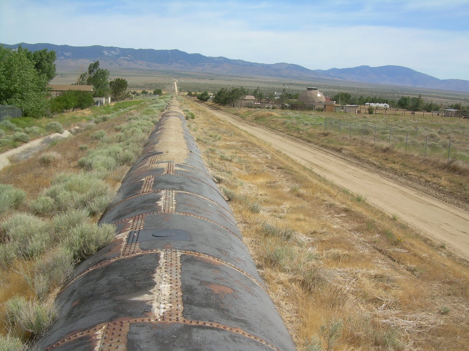
When I hit the aqueduct, I was surprised to see that it was open. I heard that the water from the aqueduct wasn't accessible, hidden away underground, so the fact I could see the water took me by surprise and I thought maybe it wouldn't be so bad after all. I got my hopes up for nothing, however. A mile or two later, the trail turned off the open aqueduct and started following the Los Angeles Aqueduct--which was hidden away in a giant, mostly-buried tube. The top couple of feet of the tube protruded above the ground, and most of it was covered by an additional layer of dirt, following alongside a dirt road.

The tube looked easier for me to walk on than the loose dirt on the road, so I scrambled up to the aqueduct and walked directly over it. Endless water flowing under my feet, and not a drop to drink.

It was interesting to hike on, and a stiff breeze helped keep me cool. Some areas, where the layer of dirt had worn off, were a bit more challenging to walk on because enormous rivets held the tube together right where I wanted to put my feet. It hurt to walk directly on the rivets, so I'd try to walk around them as best I could.

I got off at one point when the tube crossed over a dry creek bed. From the top of the tube where I was walking to the bottom of the creek bed was probably a good 20 or more foot drop, and one slip and fall could have had tragic consequences. No, better safe than sorry. I walked down to the road bed, crossed the dry creek, then clambered back up on the aqueduct.

The aqueduct went for a few miles, and I could see a hiker far in the distance in front of me. A lone dot on the dirt road, slowly moving. I couldn't tell who it was from that distance, but there was at least one hiker relatively close by.

The aqueduct then changed, to a type that involved lots of concrete in piles and lumps that made walking over it progressively more difficult, and I finally went back down to the dirt road to walk the rest of it.

That part didn't last long, however, before the aqueduct made a sharp right turn, and changed form again. This time, to go under a what looked like a road of concrete. An occasional access panel would allow workers to get into the aqueduct, but the enormous concrete blocks would have been impossible for hikers to lift. Other access panels that were smaller were locked with padlocks.

This part of the aqueduct looked a lot newer than the other parts I walked on, and I spent most of the afternoon wondering how much water was flowing beneath my feet. Where was it headed? When was the aqueduct built? I couldn't get answers to any of my questions, but I found myself very curious about the politics, the construction, and the story of the aqueduct.

But the hike was brutal. It was boring and flat. I first walked on the concrete layer covering the aqueduct, enjoying the clicking of my shoes against the hard concrete. (Lest you've forgotten, the soles of my shoes were wearing out and metal strips were sticking out of them, which made a nice clicking sound whenever I took a step on a hard surface such as concrete or solid rock.)

But walking on concrete for long periods started hurting my feet, so I finally veered off onto the dirt road next to it. Shade was non-existent. Perhaps one could make do under the shade of a small Joshua tree if it were necessary, but there was nothing around to create shade. The aqueduct would pass by the occasional house, and I wondered who would find themselves living out there.

Then I saw it. Movement. An animal ahead, in distance. A wolf? A dog? Yes, a dog. Running lose. Damn. I hate dogs that are running loose. Then I saw another one. And another. In all, four dogs running loose. They didn't seem to notice me--not yet, at least, and I stopped to watch. They looked like they were moving across the aqueduct, not along the aqueduct, and maybe if I waited a few minutes, they'll move off and I can sneak by.

So I stood, and waited, and the dogs moseyed off the aqueduct, but not terribly far from it. Not as far as I wanted. Hmm.... I looked around, checking for fences I could jump on or over if the dogs should decide to attack. I started looking for rocks I could throw at them to defend myself if it were necessary. Ready, I started walking. I walked on the dirt road so the clicking of my shoes wouldn't alert the dogs to my presence. I picked up my trekking pole, so it would clatter on the ground as well. And I sneaked past the dogs.

I saw one of them jump from a small ledge--or maybe it was pushed by another dog--and fell into a little drainage ditch with a plume of dirt rising where I lost view of the dog. Interesting..... But I managed to get by without drawing their attention. Whew.

Lest you think I'm a little paranoid, and honestly, I probably am a little overly sensitive to dogs running loose after my experiences on the Florida and Alabama Trails, but later I heard that one hiker was attacked by a dog running loose along the aqueduct walk. One of the same dogs I saw? I don't know, but maybe.... Fortunately, the hiker got away without any serious injuries, but dogs running loose like that--I don't like them.

My guidebook described a "concrete bridge" ahead that's a landmark for where the trail gets off the aqueduct for a few miles. It didn't say anything about there being shade at the bridge, but I felt that was my best shot at finding a shady place to stop for lunch. Where there are large volumes of concrete formed into a bridge, there's usually shade nearby. I hoped it was true.

About a half mile from the concrete bridge, however, I saw a pile of--what appeared to be--trash on the side of the road. Looked like a white tarp wrapped around something. As I got closer, I started thinking it looked vaguely like the shape of a human torso, but surely there's not half a dead body laying out here. A whole dead body, perhaps, but only half of one? No.... I got closer, and finally recognized it as a backpack, even noting a trekking pole coming out of it. Hmm.... That's a strange place for someone to abandon their pack, I thought. I continued to close in, and finally saw a little under the tarp to see Go-Go hunkering down in a crack caused by erosion, using his groundsheet over the top of the crack to provide shade.

"Hey, down there!" I called. "How's it going?"

Go-Go seemed surprised by my arrival, not realizing I was so close behind him. He was the person I'd seen walking up the dirt road while I walked on the tube part of the aqueduct. He said he only set up his little shade protection about five minutes earlier, but that I was welcome to squeeze in and make myself at home.

I climbed down into the crevice, but told him that I was holding out hope for a "concrete bridge" that should be located a short ways ahead. He didn't know about the concrete bridge, though, but thought it sounded a lot more comfortable than his little setup. "I might join you there shortly."

Which I didn't have a problem with, but I did warn him that I couldn't be certain that there was usable shade or what the situation at the bridge would be like. My book just said there was a concrete bridge, not that there was actually shade. I was making some huge assumptions that there might be shade.

Go-Go looked so cute hidden under his tarp there, and I told him so. "I need a picture of this," I said as I pulled out my camera.

Go-Go laughed at me. "Cute? That's funny as hell!" Then he took out his camera. "Can you get a picture of me with my own camera too?" Sure.... So I took pictures, then continued along the aqueduct.

Technically, it was concrete. And technically, it was a bridge. What I did not know, however, was that the bridge was only one or two feet high over the aqueduct. I could lay down under the bridge, but I wouldn't be able to sit up in the shade. Hmm.... Less than ideal, but technically, it was shade. Even if I had to lay down on the aqueduct to get at it.

I decided to set up my tarp adjacent to the bridge, using the bridge to anchor down one side and giving me a small bit of shade that I could actually sit up in. I was putting in the last stake when Go-Go walked up, laughing, "That's funny as hell! What are you doing?"

"I'm turning lemons into lemonade," I told him. "Come on and join me. It's the best shade you're going to find."

Go-Go ended up scooting under the bridge, while I spent my time resting under the shade my tarp provided. The shade under the bridge was a bit cooler, but I liked being able to sit up. Twice, a strong wind gust blew out one of the stakes anchoring down one corner of my tarp and I had to go out to fix it. "Damn wind," I grumbled.

Go-Go reported that his little pocket thermometer reported that it was 96 degrees. In the shade. Ugh.

I pulled out a 15-ounce can of sliced peaches I had bought in Agua Dulce. "You see this?" I asked Go-Go. "I'm having this for lunch. Yum!"

Go-Go seemed astonished that I would carry such a heavy food item, and laughed again about it being as "Funny as hell." The peaches were absolutely delicious. An absolute delicacy in our current situation. I ate them up, along with some other snacks and washed it down with water. I figured my pack weight would be over a pound lighter when I left the concrete bridge than when I arrived, and that's awesome!

We stopped for a couple of hours before I broke down the tarp and we continued along at our own pace. The trail left the aqueduct for a few miles. I didn't know the reason for the 'detour,' but I followed it anyhow. Later, seeing where the aqueduct passed through from a distance, the ground looked all tore up from off-road vehicles, and I suspect the reason for getting off the aqueduct was to avoid the off-road playground for motorized vehicles.

After a few miles, the trail rejoined the aqueduct, and a few miles later, we finally reached the Cottonwood Bridge, a paradise of shade and water, 17 miles beyond Hiker Town. A faucet provided water from the aqueduct, with a stern warning the water should be treated before being used. This bridge provided plenty of shade where the aqueduct crossed a small, usually dry creek (though it wasn't dry when I visited). I set up behind a shade screen, which also acted as a wind break against the increasingly strong winds.

I decided to cook dinner there, where water was plentiful and I had such an excellent wind break. A few hikers arrived, but they sat out in the sun on the other side of the creek. Fools! Hahaha!

Originally, I wanted to hike a few more miles, but I decided that the wind break was wonderful, and I'd be very unlikely to find better wind protection further along the trail. It was whipping, ripping through the trees with a ferocity of a wild dog, and the weather forecast called for a wind advisory. Yes, I liked my little wind break. I'd spend the night there.

No other hikers stopped there for the night, but I did meet a couple of local kids who drove out to this remote location to smoke pot. They offered some, which I declined, but I encourage them to sit down and tell me about themselves. It's lonely hiking out by oneself, and I'd be more than happy to chat up the potheads for lack of anything better to do. =)

They finished their pot, though, and left. I watched the sun set, then went to sleep.