Monday, December 28, 2020

Day 90: The Sky is Falling.... err, I mean the End Is Here!

September 7: I woke up to--shockingly--a clear and sunny morning! It was the first morning along this entire coast walk that actually started with clear, blue skies. It seemed fitting for what was expected to be my last day on the trail. So I definitely woke up in a good mood! =)

The morning had clear skies! What an auspicious start to my last day on the trail!

I hit the trail early as well. Again, I needed low tides, but I was sure I could get by even if I slept in for an extra hour or two. I got an early-morning start mostly because I was anxious to finish up this trail. 

After leaving Yellow Bank, the coast became rocky, slippery and difficult. I didn't travel quickly along this section, but it didn't last long before I reached a nice, sandy beach that lasted several miles to South Point. This beach seemed crowded with perhaps hundreds of campers! It was insane the number of people camped out here, but the location was just a few easy miles from the trailhead and it was Labor Day so I wasn't surprised about the crowds. It just felt weird to see so many people camped along this particular stretch.

Amanda, I knew, should have been camped somewhere at South Point two nights ago. She wouldn't be there now, though, so I didn't look for her. She was supposed to have camped at Wedding Rocks another mile or two up the coast last night. If she was still in camp, that's where I would find her.

After passing South Point, the sandy beach faded out and turned into the rocky mess that was difficult to navigate once again. If Amanda wasn't still in camp and sleeping, I figured I'd probably catch up with her somewhere along the hike to the trailhead. I knew she wouldn't be moving quickly over this rocky terrain.

I pushed onward, eventually reaching the Wedding Rocks camp. I saw one couple camped nearby, but there was no sign of Amanda. It wasn't particularly late in the morning when I arrived, but she must have already broke down camp and started hiking. Amanda must have gotten an early-morning start as well.

The next couple of miles continued to be slow-going--a rocky, slippery minefield that was impossible to travel quickly on. It actually wasn't as bad as the terrain yesterday or even that first day I hiked on the coast, but it definitely wasn't fast or easy either.

I watched my GPS as Cape Alava, the official end of the Pacific Northwest Trail, crept closer and closer to my location. First it was a mile away. Then a half mile. Then a quarter mile.

In the distance, I could see a point of land jutting out into the ocean, as if pointing to an island just offshore. That must be it: Cape Alava. The end of the trail. Cape Alava is the westernmost point of land that is part of the contiguous United States. Never before have I ever traveled so far west in the contiguous United States.

I saw a hiker ahead of me, but I couldn't tell if it was Amanda or not from this distance. But I was closing in on the distance between us and eventually realized that no, it wasn't her. Amanda was still MIA. 

I also passed a family of four, the mom, dad and two kids, and the mom asked me if a reddish pile of poop was bear poop. "Yes," I answered, "I believe it is." You could still berries and such in the poop, and I knew bears often visited the beach. "I even saw a bear on the beach yesterday," I told her. "They're definitely out here!"

I finally reached a small trail leading into the woods marked with the symbol to mark inland trails. I'd have missed the trail completely if it wasn't for the symbol. It kind of sneaked up on me, and I suddenly realized that this was it! This was the end of the trail!

There's no sign or marker to mark the end the western terminus of the 1,200-mile Pacific Northwest Trail. Just an empty, rocky beach. I sat down on a large piece of driftwood just to soak in the moment. I made it. I finally finished this trail. It took me two years. And technically, I wasn't a thru-hiker anymore. I was a section hiker. Or specifically, a "LASH"-er. A "Long-Ass Section Hiker." (It's a real term! You'll hear people use it!)

It was a quiet ending. A cool wind blew over the beach. The offshore waves were broken by the rocky shoreline far in the distance so I didn't even really hear the crashing of waves. A few people, I could see were camped further up the beach, but at the official end of the trail, I had arrived alone.

I stand at the end of the Pacific Northwest Trail, and the westernmost point of the contiguous United States at Cape Alava. From the Continental Divide to the Pacific Ocean, this trail is done!

About 5 minutes later, the family of 4 caught up with me and they were about to blow by when they asked about how much further Cape Alava was. They had camped at Wedding Rocks the night before which didn't have a water source and they were low on water, but knew there was supposed to be water at Cape Alava. I told them that I wasn't sure--I hadn't seen the water source, but it was certainly nearby somewhere.

They had not realized they had already made it to Cape Alava, and the mom was surprised when I pointed to the trail behind them. "That goes to the Ozette trailhead?"

"Yes," I replied. "I believe so. At least that's the direction I intend to go to get to the trailhead."

The whole family seemed excited that the rocky beach was done--and surprised that they had already reached Cape Alava. "We thought we still had another mile or two to hike! We could have kept on walking along the coast and would have had to backtrack!"

They seemed very happy that I was there to keep them from going astray, but it led me to worry about Amanda. What if Amanda missed the turn and kept hiking up the coast too? Was my ride home wandering around in the wrong direction and lost on the beach or already back at the trailhead and waiting for me at the car? I had kind of expected to catch up to her by this point. Maybe she didn't end up making the entire loop at all for some reason? She could have decided that this rocky beach was hell and turned back and went back the way she originally came? (Amanda's route would have covered a roughly triangular shape with about 3 miles on each side of the triangle.) Or maybe she slipped, fell, hurt herself and had been evacuated out yesterday? Or something.... I had no way of knowing where Amanda was without a cell phone signal.

The family went up the trail a bit and came back to tell me that they found the water source. Awesome.

I took a few photos of the area, then headed up the trail myself. Although the PNT was now officially done, my hiking was not since the trailhead was located about 3 miles away.

Those last three miles were extremely flat and easy, though, and almost entirely boardwalk. Mile after mile of boardwalk. The most challenging part of the hike were the wet areas on the boardwalk that caused the boards to be slippery, but I moved very rapidly. My pack was essentially empty of food now, and therefore very light.

It took me less than an hour to reach the trailhead, where I found Amanda taking a nap in the driver's seat of her car. "Knock, knock!" I told her. "The trail is DONE!" I reported. =)

I took off my shoes and jumped into the car, ready for the long drive home. Goodbye, PNT!

Along the drive, Amanda and I shared our adventures with each other. The last time I had spoken with her was when I was in Forks, before I had started any of the coast walk so I had plenty of stories to share. And she had spent the last two nights, as planned, camped at Sand Point and Wedding Rocks and had her own adventures to share. She even had a ranger check her permit at Sand Point, and I felt a little cheated that I never did have a ranger check my permit. On the other hand, I also never camped at such a busy and accessible location as Sand Point.

The rocky beach--especially the section between Wedding Rocks and Cape Alava--she hated. It was hard she informed me. "Yeah, I know!" I told her. "I just did it too!"

She had also seen a bear on the beach as well, but only from a far distance. It was a tiny dot perhaps a quarter-mile away, but still, a bear sighting is a bear sighting! And at least she got a photo of the dot. I didn't get any photo at all of my bear on the beach. (At least I got a better view of it, though!) You can read about Amanda's adventures on her blog.

I thought we were leaving the trail, but I recognized many of the names and places on the drive out. We drove through Sequim--the same trail town we had stayed in for two nights a couple of weeks earlier. We crossed the Elwha River--which I had hiked alongside of for about 30 miles. We crossed the Dungeness River--my access point into Olympic National Park. And at Discovery Bay, we even drove on the PNT for several miles where it followed Highway 101. It seemed almost impossible to avoid the PNT on the Olympic Peninsula--not that I wanted to.

We took the Southworth ferry back to Seattle. Since they preferred people in vehicles to stay in their cars rather than wander around the ship, I ended up watching the scenery go by while standing next to the car at the side of the boat. There was a faint tinge of smoke on the horizon--little did I know at the time how much worse the smoke from distant forest fires would be just the next day. In hindsight, I got off the trail just in time to miss the truly horrific smoke that would plague the area starting the next day.

My view from the Southworth ferry. Notice the hint of smoke on the horizon? It would become a lot worse starting tomorrow!

And then finally, we arrived back at the house where I took my first shower since Forks and could begin resettling back into my normal routines. The PNT was now officially behind me. =)

But it's never far away. Every clear day, I can see the Olympic Mountains on the horizon, or Mount Baker to the northeast--daily reminders of my adventures on the Pacific Northwest Trail. Those areas seemed so remote when I walked through them, yet there are they in plain view from home in Seattle on any clear day.

But now I have a new problem to figure out.... what will I hike next? Hmm..... =)

In other news.... I did carry a GPS the entire distance which tracked my every move. After stripping out pee breaks, side trips (towns, mountain peaks, campsites, water, etc.) and other rest breaks, these are some of the cumulative stats my GPS recorded about the entire PNT: 

Distance: 1,228 miles

Elapsed time: 90 days, 12 hours, 2 minutes and 57 seconds

Moving time: 19 days, 9 hours, 7 minutes and 6 seconds

Average moving speed: 2.6 mph

Max speed: 34 mph (that must have been when I road the ferry across Puget Sound because I certainly didn't walk that fast anywhere!)

Max elevation: 7,523 feet above sea level

Min elevation: 47 feet below sea level. (Clearly not a super precise measurement!)

Ascended: 205,853 feet (Approximately 7 times from sea level to the top of Mount Everest)

Descended: 211,718 feet (5,865 feet more than I ascended--which makes sense since I hiked from the Continental Divide to the Pacific Ocean)

In other news.... if you have any interest in virtually walking this trail, it is available for walking on Walking 4 Fun!

If you are interested in hiking the trail in real life, I'm providing my actual PNT GPS tracks for free to download. You'll want more than this for navigation purposes, but it could be useful at times. =)


I didn't see anymore bears on the shore today, but I did catch these two deer out here!

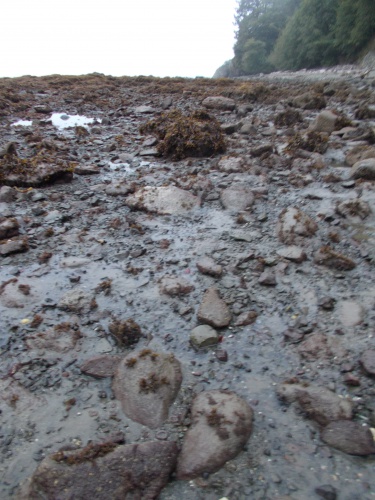
This terrain is terribly difficult to navigate!

The three miles from Cape Alava to the trailhead were almost entirely boardwalks like this. Super easy to hike!

Even the areas that weren't boardwalk were still super easy to hike!

Ozette River

The Cape Alava trailhead and, although it's not the end of the trail, it is the end of my hiking!

My GPS recorded this startling elevation during the ferry crossing of Puget Sound. It's never a good sign when you're 197 feet below sea level and on a boat....

What the heck happened at home while I was gone?!!!! A water heater in an apartment above broke and sprung a leak. I knew this had happened before I arrived, but it was the first time I'd be seeing the damage myself.


Friday, December 25, 2020

Day 89: The End is Near!

Merry Christmas, everyone! I bet nobody reads this blog post today as y'all be out playing with your new toys, but just in case....one of you are still checking up on me, I'll post anyhow. =)

September 6: I woke up and hit the trail relatively early at 7:00am, again hoping to take advantage of the morning's low tides as much as possible. Krista was stirring when I left so we said goodbye to each other, and I wished her luck on future backpacking adventures. She seemed quite satisfied with her first night in the backcountry. Paul and Marshall were still asleep as far as I could tell so I didn't bother them on my way out.

Woke up to a cold and foggy morning

The weather was dreary and foggy once again--seemingly a regular condition each morning on the coast. I hoped it would clear up later in the afternoon.

The trail out from the Chilean Memorial Camp passed around a difficult, rocky cape and the going was slow, but the other side of the cape turned into a simple and pleasant beach walk.

Until.... I reached the Norwegian Memorial Camp--another campsite dedicated to a shipwreck off shore eons ago. A Norwegian ship, no less! You'd think a Norwegian ship would have made a special point to avoid any location known as the "Norwegian Memorial" while sailing through the Graveyard of the Pacific....

But anyhow, the shoreline for the next four miles to Yellow Bank was absolutely awful. A rocky hell, difficult and slow to navigate. I can't say that I was surprised--my map warned that this section was particularly difficult and I had been dreading it for days. Because, shockingly, my map didn't warn about other difficult sections of the coast such as the area I passed through yesterday. If there was a special warning for this section, I thought, how much worse could this section possibly be than yesterday?!

As it turns out, I don't think it was anymore difficult than earlier sections, but it was still plenty difficult and the going was slow. My pace slowed to about 1 mile per hour at best, and hour after hour I struggled along the terrain.

I passed a few people heading in the other direction, proof positive that there was an end to the hellish terrain somewhere ahead. I joked with them about what they did to deserve being stranded out here.

A few hours into the section, I was navigating through some particularly deep seaweed, postholing through it, in fact, and watching my footing carefully when a loud crashing sound along the shore startled me. I looked up and saw a bear scrambling up the steep cliff. A bear! On the beach! I tried pulling out my camera, but it was too late. He had already scrambled up the cliff and into the trees. He couldn't have been more than about 15 feet away and I slapped myself for not noticing the bear sooner. He had been in plain view, but I was too busy looking at my feet and the seaweed and had been completely oblivious to the bear 15 feet ahead of me. It would have been a fabulous photo.

You can't see it, but there is a bear behind that tree!

Happy to see a bear but disappointed not to have gotten a photo, I continued the march.

I finally arrived at Yellow Bank where a real sandy beach welcomed me. I felt so liberated from the rocky expanse I had spent the previous 5 hours navigating.

And... Yellow Bank was officially my campsite for the night. I was done for the day! Or... was I?

I had planned to finish the trail tomorrow, and Amanda had planned to pick me up. But she didn't want to just do a long drive to pick me up then a long drive back to Seattle. She wanted to make an adventure of it and had dreamed of hiking a triangular 9-mile route around Cape Alava that she had heard about years earlier, so she planned to drive out a couple of days early and do the loop herself. I hadn't been able to contact her since neither of our phones would get a signal in the wilderness out here, but... in theory, Amanda was supposed to be camped just a few miles further up the coast. If everything had gone according to plan, she should have camped at Sand Point last night then would be camped at Wedding Rocks tonight. Then we'd both hike out at the same point tomorrow.

It was still early enough in the day that I felt I could have made it to Wedding Rocks today, then I could catch up with Amanda and have that much less distance to hike out tomorrow. And I was a little worried about Amanda. I had seen the coast, and I knew it was difficult. And--my map warned of another particularly difficult section for those few miles between Sand Point and Cape Alava. Amanda, I knew, would not be enjoying this type of terrain. I wanted to catch up and make sure she was okay and help if I could. 

And heaven forbid if she had to navigate one of those ropes up or down a cliff. I remembered one in particular I passed earlier that, when I saw it, my mouth dropped open in shock and I said--out loud: "Oh, hell no! What the f***?!" Fortunately, it was a low tide and I was able to walk around that headland without having to navigate those particular ropes. Some of them were positively insanely steep and crazy to do. I didn't even want to do them!

So I kind of wanted to keep going. Not just to help Amanda if she needed it--perhaps carry some of her gear since my pack was now nearly empty of food--but also so I had less ground to cover and could get done with this trail that much sooner. I was ready to be done!

But for the time being, I decided to take a lengthy rest. I was exhausted after covering this terrain and now the tide was quite high and blocking the route ahead. I could rest for two or three hours and make a decision then--but I was inclined to push onward.

So I threw out my groundsheet on the beach, kicked off my shoes, pulled out my Kindle, put on a jacket, and killed some time. The weather was still overcast and cold--perfect vampire weather. 

My right foot was giving me trouble as well. When I took off my shoes and socks, it looked like the top of the toes of my right foot had a rash. I had no explanation for it and no idea how to treat it except to stop walking so much. It was more of an annoyance than anything, but it bugged me that there didn't seem to be anything I could do about it.

The top of the toes of my right foot were causing me trouble.

About three hours later, it was do or die time. The tides were receding once again and the shoreline ahead should be passable. However, the sun still hadn't come out. And, in fact, it had grown even foggier than when I first arrived! Visibility was absolutely terrible. Fat droplets of fog hung in the air making everything feel wet. It had gotten so bad, I even set up my tarp on the beach to help keep dry while I was waiting.

And I eventually decided to stay put. The weather would likely still be foggy and overcast in the morning--every morning was foggy and overcast--but at least there was a hope it might burn off before I finished the trail. That clearly wasn't going to happen today. And--added perk!--I could camp legally here. =) And the morning's low tides were lower than the afternoon's low tides, so waiting until morning might make the next section a little bit easier.

So my temporary rest camp became my permanent overnight camp. I enjoyed the company I had the previous two nights, but this time I camped alone. There were a few others camped at other parts of the beach, but I didn't know any of them nor had I crossed paths with them earlier, nor did they drop by my campsite to introduce themselves. So I just kept to myself and watched Netflix shows and read my Kindle late into the evening.

And, if all went well, I'd be finishing this trail tomorrow! Tomorrow! What a struggle it has been, but the end is near!


I'd been seeing these tracks in the sand the entire coast walk, but I couldn't figure out what had created them. They almost looked like bicycle tracks except that they were so irregular and that there were no bikes on the beach. Any guesses to what made them?

I finally figured it out today when I caught a crab making one. Ah-ha! They're crab tracks! Of course! Why hadn't I thought of that earlier?


No, I didn't make these "crop circles." Some other people camped on the beach did!

Dead octopus on the trail

Dead jellyfish on the trail

Although I didn't get a photo of a bear, there were plenty of opportunities to get a photo of bear poop!

I don't know what this chain came from, but with this section of coastline being known the Graveyard of the Pacific, I have to wonder if it came from a shipwreck.

The weather never improved all day. Perfect vampire weather!


I'm hanging around Yellow Bank camp, trying to decide whether to keep going or stop for the night. And beard...your days are numbered! =)

Wednesday, December 23, 2020

Day 88: The Detour around La Push

September 5: I woke up and hit the trail at a relatively early 7:00am to take advantage of the low tides. Taylor and Jeremy were still in their tent when I left, but I heard movement inside and knew they were awake so I said goodbye on my way out.

The sky was overcast and cloudy--perfect vampire weather--but was expected to clear up later in the afternoon. I hoped that would be true. I didn't want to be ambushed by a vampire later.

The trail followed the shoreline to Scott Creek--the campsite where I was supposed to camp last night. Then it went inland for a bit before returning to the shore at Third Creek. For the most part, the walk was easy and fast but there were hoards of people camped on the beach. Many of them were still in their campsites, warming by fires or eating breakfast. Some, undoubtedly, were still in their tents and hidden from view. This was definitely a more crowded part of the park!

At Third Beach, the PNT headed inland again to a trailhead where the hoards of campers had originated and the trailhead was packed with people and vehicles. It was such a zoo, there was even a ranger to keep the peace and direct traffic--the first ranger I had seen in the Olympics.

I took a seat on a nice sitting rock at the edge of the parking lot for a quick snack break--the last decent place for me to sit for miles that wasn't along a busy road walk. The ranger asked if I was leaving--not that he was anxious to get rid of me, but rather, he explained, that the line of cars at the edge of the parking lot were people waiting for a place to park. They had permits to camp to Third Beach, but the parking lot was full. And, in fact, several vehicles had already parked illegally, their vehicles hanging out in the road that went by. They had parked there before the ranger arrived and told them not to.

I explained that yes, I'd be leaving, but unfortunately it wasn't going to make a parking spot available since I had no car. I think the line of people waiting for a legal place to park were disappointed when they realized that my arrival wasn't going to move them up in line! (On the other hand, I hadn't been contributing to the parking problem in the first place!)

The line of cars on the right were waiting their turns for a legal parking spot to open up.
 

The ranger seemed sympathetic toward the people waiting to park, and even sympathetic toward the people who had already parked illegally saying that it was really the park's fault for issuing more permits than the trailhead could handle, but that they just couldn't allow people to park where it would impede traffic along the road.

I had, in fact, received an email from the park service when I was in Forks saying that people should not park along the road at this trailhead and that illegally parked vehicles would be towed. They sent it to me since their records showed that I had a permit to camp near it for Labor Day weekend (today was the Saturday of Labor Day weekend)--an automated message which didn't apply to me since I didn't have a car.

Anyhow, I finished my snack and then continued onto the road walk. And it was a miserable road walk, along a busy highway with almost no shoulder on Labor Day weekend. There's absolutely nothing good I could say about this road walk except that I knew it would be the last road walk of the entire trail. Woo-who!

The primary PNT headed west along the road toward the town of La Push, but I veered eastward toward Forks along a longer alternate route. La Push was part of the Quileute Indian Reservation, and they decided to close their borders to non-tribal members when the pandemic started. The primary PNT route was officially closed to me, so I headed around on the miserable 8.8 mile alternate road walk instead.

A half hour later, I saw a tow truck heading in the opposite direction toward the Third Beach trailhead and wondered if they were starting to tow the illegally parked vehicles. Someone I passed who was camped at Third Beach wasn't going to be a happy camper when they got back to the trailhead!

About 20 minutes after that, I saw the same tow truck heading back toward Forks--this time, towing a vehicle. I don't know for certain that the vehicle came from the Third Beach trailhead, but if I could place my bets, I'd say it was.

The route around the Indian reservation actually left Olympic National Park, but I would re-enter the park near the end of the road walk.

Halfway through the road walk, the trail reached a junction where I would change roads to one heading west back to the coast, arriving at the coast just north of La Push. But, more important, there was the Three Rivers Resort at the trail junction. It had everything! A restaurant, gas station, convenience store and lodging. The restaurant was tempting--I liked the idea of having a real meal for lunch--but this road walk was a long one and I had quite a bit of miles to cover to reach my campsite before a high tide stopped me short. I just didn't have the time. Instead, I settled for the convenience store and bought a cold Coke. While waiting in line--the gas station was packed with passing tourists--I noticed a Hostess cherry pie and grabbed one of those horrible things as well. I knew it was horrible, but I just had an urge to eat one anyhow. I couldn't help myself. This was my last few days on the trail. If I wanted to eat crap, this was my last opportunity! At least the last opportunity that I could eat such crap without feeling the guilt. =)

This is the convenience store at the Three Rivers Resort. That's my pack and trekking pole next to the bench. =)

And I liked the idea of buying a "pie and pop." I imagined a tourist walking by and asking me, "So what do you eat on the trail?" And I'd answer, "Well today? A pie and a pop." =)

That never happened, but a guy can dream....

I ate my pie and drank my pop on a bench in front of the store. Although the store and gas station were packed with passing tourists, they were all passing through in vehicles and I had the bench all to myself.

Although this wasn't in Forks, it was close enough that the resort definitely catered to Twilight fans. A large banner by the road read "Welcome Twilight Fans"--which also, apparently, marked the treaty line between the werewolves and vampires. Another large sign proclaimed "Stephanie Meyer Day" which seemingly thousands of fans had signed. Even one of the cabins by the gas station, I could see through the trees, was called "Jacob's Den." It was near the giant bigfoot wandering through the camp. As if werewolves and vampires weren't enough to worry about. ;o)

Anyhow, after finishing my pie and pop and taking a few photos, I continued the road walk--now heading west back toward Olympic National Park and the coast.

The road walk ended at Rialto Beach, but I could tell the place would be a madhouse of Labor Day crowds nearly a mile before that due to the long line of vehicles parked on the side of the road. Although the Third Beach trailhead didn't allow parking on the side of the road, that rule apparently did not apply to the Rialto Beach trailhead. It seemed like hundreds of vehicles were parked along the side of the road which I found incredibly annoying because it meant I had to walk in the road rather than along the shoulders. And did I mention how busy the road was?

Eventually I reached Rialto Beach. At least I didn't have to worry about finding a place to park. It seemed like dozens of vehicles were driving around in circles hoping for a spot near the trailhead rather than parking along the road as much as a mile away.

The trailhead at Rialto Beach was packed with vehicles driving in circles looking in vain for a place to park.
 

By the time I arrived at the beach, though, the tide was nearing its high point for the day and I feared my route ahead would be blocked. I was tired having taken nothing more than micro-breaks during the day. My longest break--at the Three Rivers Resort--was only about 15 minutes. I was tired and needed a break anyhow.

So I found a location near some driftwood, as far away from others as I could. Which wasn't that far--the nearest people were probably 20 feet away. The sun had finally come out and so I pulled out my umbrella for shade. I had no doubt that everyone would think I was a vampire--covered with a long shirt, pants and then an umbrella as soon as the sun came out. What else would they think?!

I wound up laying about for a couple of hours, waiting for the tide to recede. I read a lot from my Kindle to pass the time. Occasionally I looked up to watch surfers riding the waves offshore. After a couple of hours, though, it was time to hit the trail again.

The beach walk started off nice enough. It was a nice, sandy beach. Parts were covered with pebbles, but nothing particularly difficult or problematic. My biggest annoyance were the hoards of tourists on the beach.

But after passing Hole-in-the-Wall, the trail became a truly horrible experience. Large, rocky boulders blocked the route. Getting through them was like navigating a maze of wet and slippery rocks, scrambling over and around them, and often under giant driftwood. Sometimes I needed to take off my pack to get through a tight area. My progress slowed to a crawl. On the plus side, however, the day visitors basically stopped at the beach. At least the rocky area wasn't crowded with people.

I wound up meeting a few other hikers heading in my direction: Krista, Paul and Marshall. The first time I approached them across this rough terrain, I joked, "So did you lose a bet too?" Implying, of course, that nobody would voluntarily hike over such rough terrain.

We passed each other a few times over the next couple of hours and I chatted them up every time we passed. Paul, I learned, was suffering from some horrendous blisters despite the fact that they only started their trip at Rialto Beach. Krista, I learned, was on her first backpacking trip and seemed quite excited about the opportunity. Marshall, I learned, had recently moved to Seattle from Colorado.

Late in the afternoon, I started to worry about reaching my campsite before sunset, and I tried to pick up my pace a bit. This terrain was taking me considerably more time to navigate than I had anticipated!

I arrived at the Chilean Memorial Camp, named in honor of a Chilean ship that had sunk just offshore a hundred years earlier or something. This stretch of shore, after all, wasn't called the Graveyard of the Pacific for nothing. I arrived only about 10 minutes before the sun set. Just in the nick of time!

I arrived at camp with just minutes before the sun set.

The three hikers I met arrived about 15 minutes later and I said that they were welcome to take the campsite next to mine if they wanted it, but they went further up the beach to look for other options before coming back about 5 minutes later and asking if I was sure it was okay.

"Please! I've been hiking by myself for over 40 days! I want company!"

They started setting up camp, but Marshall struggled getting his tent up. It was a borrowed tent that he had never set up before and he didn't have the directions for it. Krista came by to help, and I watched, amused, as they struggled to erect the shelter. Finally, Paul limped over to also help, and they looked at me asking if I knew how to set it up--as if with all my backpacking experience, I should know how every tent works. But I didn't--I only carried a tarp and have rarely set up actual tents.

I watched them for another 5 minutes or so, as they complained about how this was the most confusing tent they had ever seen when Paul suddenly realized what the problem was--they were setting up the rain fly! The tent was in a pile off the side. They had been setting up the rain fly rather than the tent the whole time!

I bust out laughing--a loud, hearty laugh. I couldn't help it. It was hilarious. I wasn't laughing at them per se--even they could see the humor in it. "You'll be telling this story to friends and family for years!" I told Krista. 

After getting their tents set up, they decided to make a campfire which they welcomed me to join. Before I did, though, I wanted to finish writing up my journal entry for the day so I scribbled away. Once I joined them at the campfire, I wanted to stay up as long as I wanted without anymore "camp chores" to worry about before bedtime.

After finishing my journal entry, I joined them at the campfire where we chatted and enjoyed the evening for a couple of hours before calling it a night. It had been a long, rough day, but it definitely ended on a high! And, for the first time since leaving Forks, I was actually camped at the campsite I was supposed to be camped at! I was back on schedule! =)


Can they make a trail more steep than this?!

I continued finding evidence of the PNT hikers ahead of me.

Even at low tide, an elevation of -42 feet can be problematic....

Third Beach


The park service is quite serious about no roadside parking! Some people, however, did not take the warning seriously.


Some parts of the road were even spray painted with "no parking" messages.


Along the road walk, I passed over the Bogachiel River. I last saw this river when I hiked out of Forks a few days earlier.


The Three Rivers Resort definitely had a big Twilight fan base visiting.

I didn't make it up--there really is a Stephanie Meyer Day here!

As if being attacked by werewolves and vampires weren't enough to worry about.

Crossing over the Sol Duc River, just before it merges with the Bogachiel River. (See the Bogachiel that it's merging with downstrean?)


Cars were parked on the side of the road for nearly a mile before reaching Rialto Beach!

A seemingly endless line of parked cars....

I took a long break at Rialto Beach waiting for high tide to pass.


Rialto Beach was fairly easy to walk on.


Pebble beaches were only marginally harder to walk on than the sandy beaches.


I thought this stunt was reckless and stupid. If they had fallen, it might not kill them--but it wouldn't have been pleasant either!


Tide pools!