July 22: Being camped at the edge of a meadow, it meant that there weren't a lot of trees to block the sunrise and therefore it got light much earlier than normal and therefore, I was up and hiking and on the trail at an early 5:45am! Perhaps my earliest start yet!

I followed the gravel roads, since I was still on gravel roads that detoured around the wildfire that closed the trail--now my 4th day on the fire detour--but also my last day since I expected to reconnect with the red-line CDT in a few hours. I was looking forward to getting back on the official route again. The detour, generally speaking, sucked pretty badly.
I was probably an hour into my hike when I came across a vehicle that had driven into a creek. While coming up to the scene, it looked to me like the 4-door sedan might have gotten stuck while trying to cross the creek, but the car was still idling. There, I met Chris who was getting some water among other tasks and apparently wasn't stuck at all. He had a rental car, though, and was traveling the countryside and seemed nice. But I still found it oddly unsettling that he had apparently parked his car in the creek then left it idling. I gotta imagine that the rental car company he got it from won't be too happy with his off-roading adventures when it comes time to return it.
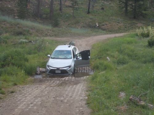 |
| When I came across this scene, I thought I had discovered a vehicle stuck in the creek. But no.... just a convenient place to park, I guess. *shrug* |
I was glad to learn that he wasn't stuck, however, since I didn't feel like I had any obligation to help someone that didn't need any. Not that there was much I could do. I didn't get any cell phone signal out here. The only way I could get help would have been to hike out on foot. If he had been stuck, he could have done that himself. But, more than likely, if he waited long enough, someone in a car would have driven up and could either help by towing him out of the creek or driving somewhere with a signal and then they could call for help.
But I continued pushing onward, and the trail steadily climbed in altitude, eventually reconnecting with the red-line CDT. Hello, trail! I missed you so.... Although in the immediate future, nothing about the trail actually changed. The trail through this area continued to follow old, gravel roads. They were, however, much more rugged and less maintained than before, which also meant much less traffic. In fact, along this gravel road, I never saw any traffic at all.
The gravel road eventually did become a proper trail, however, and I was back in my element. A few miles later, I reached another exciting milestone: Wyoming! I finally arrived at the Wyoming border. Colorado, at long last, was behind me. Good riddens! I was so over Colorado at this point and all their stupid mountains! Wyoming, if rumors were true, would be flat and easy and oh-my-gosh, I so much wanted a little bit of flat and easy terrain!
The trail, where it crossed the border, was marked with a line of stones and the abbreviations WY on one side and CO on the other. There were also license plates of both states strung up at the border. I stopped to take some photos and relish the achievement. Two states down, three to go!
 |
| The line of rocks across the trail marks the Colorado-Wyoming border. |
Then I continued onward, and a mile or two beyond the border, I reached yet another big milestone. For there, in the trail, spelled out with rocks was 1500. It was 1,500 miles from the Mexican border. At least along the official red-line CDT. At this point, absolutely nobody on the trail followed the main route the entire distance. Even if they wanted to, there was still the problem of trail closures such as the fire detour. But, in principle, I had reached the 1,500-mile mark. And roughly speaking, the CDT was approximately 3,000 miles long (again, depending on the specific route one takes), which means it was also--roughly speaking--about the halfway mark. At this point, both Canada and Mexico were approximately the same distance away.
So I did a little halfway marker dance, but soon continued onward.
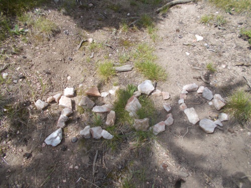 |
| 1500 miles! Roughly speaking, the halfway mark of the trail! Woo-who! |
The legendary flatness of Wyoming, so far, had been elusive. The trail wound through thick forests and rose and fell regularly. Basically, it looked like a continuation of Colorado. If the border hadn't been marked, it would have been easy to pass it and never even know it was there.
The trail eventually came out to a trailhead overlooking Hog Park Reservoir. I stopped to take a short snack break, during which a vehicle pulled up. Out of which came out a few adults and four kids. The kids, if I had to guess, ranged in ages from about 5 to 8. One of the adults asked me if I was hiking "that trail along the Continental Divide," I told him that I was. He said it was the first time in 20 years that he'd actually seen anyone hiking the trail and was immediately fascinated by it.
Once he broke the ice, though, the kids took over the interrogation. They wanted to know when I started, how long I had been hiking, what I ate along the way, where I was going after I left the trailhead and what I would do after I finished the trail. It was a very thorough interrogation! The kind that adults would never do because they'd feel too shy about asking too many questions or being too personal. Kids have no such hangups, though. The adults occasionally told them to, "Stop bothering the guy," but I assured them that I didn't mind. It was kind of cute. =)
Two of the kids wore cowboy boots and a cowboy hat and spoke with a bit of a drawl. I imagined them growing up to be the town sheriff, and were practicing their interrogation techniques on me.
The kids started giving me snacks as well: oranges, crackers, strawberries and more. I joked with one of the adults that didn't they ever teach their kids to "not feed the wildlife". =) Plus their grandmother offered to take my trash for me. I didn't have much since I had left civilization just yesterday, but I was happy to pass on what little I did have.
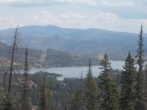 |
| The trail doesn't go to Hog Park Reservoir, but it was certainly visible from this viewpoint! |
Later in the afternoon, I was getting pretty tired and when I found a nice, grassy area among some trees, I decided to stop a bit early and set up camp. It was only 5:30pm and had only completed about 22 miles--still short of my 25 mile goal--but I was just too exhausted. I needed to stop.
I never dd see any other hikers all day. I knew Reality Check was somewhere ahead of me. Little Cave, Milkshake and Puffy probably weren't far away, although at this point I couldn't be sure if they were ahead of me or behind me. Probably behind me, but there was no way to be for certain. And if there were any other hikers within a day's walk of me, I had no idea who they were.
Having stopped early, it did allow me plenty of time to set up the bug netting that I had bought at Walmart back in Steamboat Springs. The bugs weren't bad--at least not yet--but I wanted to set it up and see how it worked in the field.
There was rain forecast for the night and by the time I stopped for camp, gray clouds had rolled in, so I set up my tarp on top of the bug net. I wasn't quite sure how I could nest the two together when I bought the bug net, but they seemed to fit surprisingly well. I imagined ways I could add attachment points directly to my tarp that would allow me to quickly and easily hang the bug net directly from my tarp. Ideas for a future time.... All-in-all, however, I really liked the setup. It was comfortable and seemed sturdy enough to keep mosquitoes away. The netting wasn't fine enough to keep out no-see-ums, but that was a problem for another trail. Perhaps I could make another net with a finer mesh for such situations? But that was a matter that I could worry about later as well.
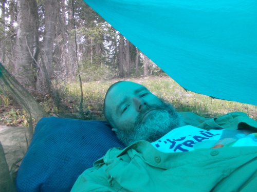 |
| Camped under my tarp, and trying out my new bug net. The bug netting isn't especially obvious in the photo, but you can see a seam for it behind my head and the fabric sloping down on the left side of the photo. |
While cooking dinner, a lightning storm rolled in. That didn't worry me too much. I was camped downhill a bit, not on an exposed hillside, and nestled among lots of trees. It wasn't a bad campsite to be in during a thunderstorm, and I rather enjoyed listening to the thunder roll through the air It was still too light to really see any of the actual lightning, though. It was mostly just the thunder I heard.
At least until I was brushing my teeth when I saw a bright flash out of the corner of my eye and before I could even react, BOOM! CRACK! I'm not entirely sure precisely where the lightning struck, but it scared the crap out of me! Way too close for comfort! My ears were ringing a bit from the thunderous boom and I wondered if I should try to move camp. Looking ahead on the topo map, however, it didn't really look like there was anything much better than where I had already set up camp so I decided to ride it out and hope for the best.
I'm happy to report that that one lightning strike was the only one that gave me cause for concern. The lightning continued, however, and as the sky darkened, the flashes of light became increasingly more prominent. Flash! Boom! Flash! Boom!
And it continued, hour after hour after hour, seemingly without end. It was really quite unusual. Although lightning storms had been fairly common in the Rocky Mountains, they almost never lasted more than an hour and often times as little as 15 minutes. This one, however, continued for hours.
After it got dark, the storm continued. I usually went to sleep by around 10:00pm, but I had trouble falling asleep with the constant booms and flashes of light. Not to mention the heavy rain that pounded my tarp the whole time. It was definitely a good thing I had my tarp up, though! I managed to stay entirely dry and comfortable.
It wasn't until 3:00am when the lightning storm finally ended. Three in the morning! That lightning storm lasted over 8 continuous hours! And, at long last, I finally fell into a deep slumber. My day was finally over.

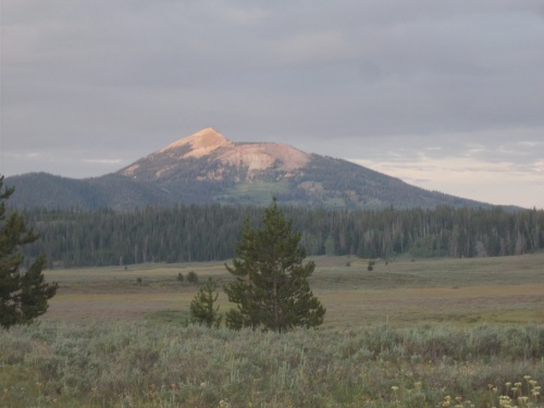 |
| That's Hahns Peak, the same peak I first saw yesterday. But now we're looking at it from the backside. |


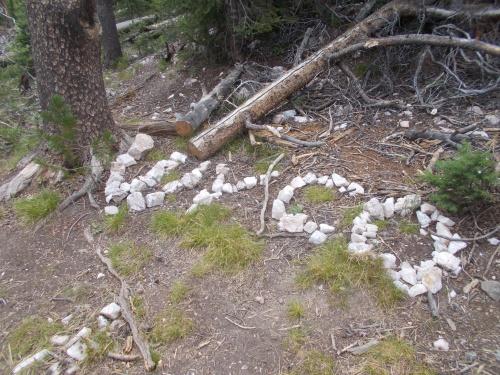 |
| Just in case you weren't sure which side of the border you were on, they labeled it with these rocks. |
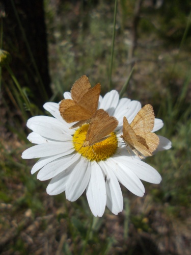 |
| Huge numbers of butterflies today! |


No comments:
Post a Comment