July 18: I had done a little math and realized that I had fallen behind schedule. Stopping early to camp at the shelter on Parkview Mountain, then stopping to chat with Colonel for 3 hours yesterday have added up to the fact that I was roughly 10 to 15 miles behind where I thought I would be at this point. Which normally wouldn't be a problem--I carried plenty of food. My problem, however, was that I had made a reservation for a hotel in Steamboat Springs and I was expected to arrive tomorrow. I was darned certain that I wasn't going to pay for a room that I wouldn't use! But when I checked my maps, I figured I still had about 55 miles to reach the town. That's a pretty long distance for two days, so I decided that today I would shoot for my longest day ever on the CDT: about 30 miles--which would leave me with 25 miles into town tomorrow.

But if I had any hope of knocking off 30 miles today, I needed an early start and therefore I hit the trail running at an early 6:00am.
Also looking at my maps, I didn't see a lot of great water options ahead for the day. I would pass some water sources, but they would be running through cattle country and farms and it was definitely not the kind of water I liked to drink. So I filled up with the water by my campsite and packed a particularly large amount of water to get me through most of the day: 5.5 liters. That's 12 pounds of water in my pack! Way too much, but it is what it is.
Just Awesome was still in camp when I left. No surprise there! Most hikers aren't on the trail and moving as early as I was this morning.
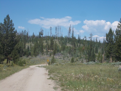
The trail climbed steeply for the first few miles, a good warm-up for the day. Then largely headed downhill gradually the entire rest of the day. At the top of the ridge, the trail connected with a gravel road, wide and easy and with the slight downhill grade, I could walk fast.
The views were a bit obscured with smoke in the air. This wasn't a bit surprise, however, since I knew the trail was approaching a wildfire. The trail was officially closed. I wouldn't reach the closed area until tomorrow, and I tried understanding the written description I found online about a reroute on my maps but couldn't really quite figure out how the written description corresponded with my maps and decided to make my own reroute which meant road-walking all the way into Steamboat Springs.
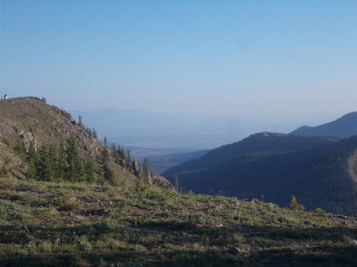 |
| There was definitely a lot of smoke in the air from nearby wildfires! I could barely see the mountains in the distance, and they weren't really that far away. |
The official trail corridor misses Steamboat Springs, but it has always been a popular resupply point for thru-hikers since it's a relatively easy hitch into town from along the trail. And I figured since I had to go into town anyhow and couldn't follow the official CDT since it was closed due to the fire, I'd just walk into town. Save myself the effort of a hitch.
In any case, I was well aware of the wildfire burning nearby, so it was not at all surprising to see smoke in the sky.
The first 10 to 15 miles along the road walk followed a gravel road. This section was easy and fast but a little boring passing through cattle ranches and farms. Occasionally a vehicle would drive by, but maybe only once every hour or two. It certainly wasn't busy! Most of the time I had shade, but that largely petered out as the trail continued descending.
The last couple of hours I was sweating bullets under the burning sun with little shade along the road for protection. On the plus side, I drank a lot more water, which helped lighten my load. =)
The last 11 to 12 miles of the day dumped me out on a busy, paved highway. That section was just positively miserable. Not only was there almost no shade and it was miserably hot, but the traffic! Horrible, horrible traffic.
About 10 miles of it was along Highway 14, which also didn't have much of a shoulder to walk on. The traffic was constant, but light enough that I often just crossed to the other side of the street to keep my distance from the vehicles.
 |
| The worst part of the day was hiking along Highway 14 in the hot sun, with lots of traffic, little shoulder to walk on and no shade. |
Near the intersection with Highway 40, I was running low on water and finally stopped at a small creek to refill again. The creek ran through cattle country and farms, though, so I didn't trust the water at all. I took the time to treat it properly, then gobbled it down. It was so miserably hot out. Ugh.
Then the road intersected with Highway 40, which I planned to follow the rest of the way into Steamboat Springs. The official CDT only followed this highway for a couple of miles before veering off onto gravel roads again, and I noticed a Guthook comment about a potential place to camp right at that intersection so I made that my goal. There was definitely not much good camping anywhere along the roads!
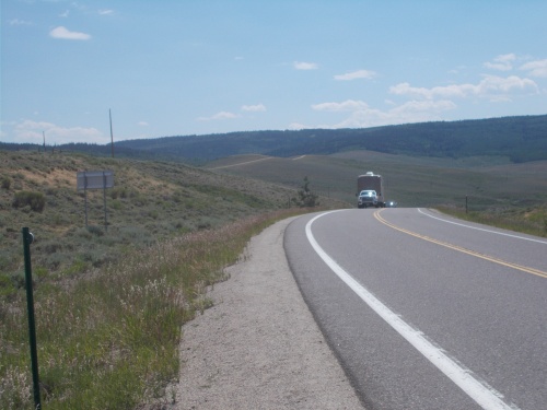
Highway 40 was even busier than Highway 14 was. On the plus side, however, it had a better and wider shoulder to walk on so I didn't cross the road to avoid traffic. There was enough traffic in any case that crossing the road was probably the more dangerous option in any case.
Anyhow, like I said, the official CDT only followed this highway for a few miles before veering off onto a dirt road. Here I did cross the highway, however, to look for the campsite which I quickly found, perhaps a 100 or so feet off the highway.
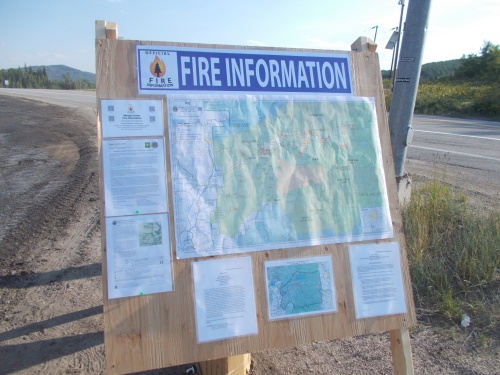 |
| The trail ahead was closed due to wildfires, but so were some roads and this board at the intersection of Highway 14 and Highway 40 gave drivers information about the wildfires. |
It wasn't a great site, but it was hidden completely from the traffic on Highway 40 which was good enough for me and I finally called it quits for the day. According to my GPS, I had completed just over 30 miles--by far my longest day on the trail so far, which logged about 66,000 steps on my pedometer. My record for steps was 70,000 back when I thru-hiked the AT in 2015, and it was a little tempting to keep going just to set a new all-time record. I knew I could definitely knock out another 4K steps if I had to, but what was the point? Torture myself further? My real longest day was probably when I covered 35 miles on the PCT in one day, and I definitely had no intention of doing another 5 miles. I'd be hiking in the dark at that point!
So I stopped and set up camp. It was about 7:00pm, a solid 13-hour day of hiking covering about 30 miles. Respectable. =)
I never ran into any other hikers all day, although I did see some hikers ahead of me who had written their names in the dirt on the shoulder of the road.
I really wanted a good meal for dinner, but I skipped it to save water and ate snacks instead.
The bugs were a bit of an annoyance. Not as bad as a couple of other nights earlier in the hike, but definitely an annoyance I would have preferred to avoid. They didn't settle down for the night until nearly 11:00pm either. Stupid mosquitoes.....


 |
| Trees became thinner and thinner the further down the trail descended. |

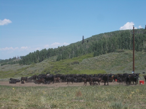 |
| Never trust the water when these guys are around! |

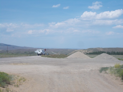 |
| I took a short break in this pullout where the end of the gravel road linked up with the paved road. From here, the trail was just a miserable grind. |


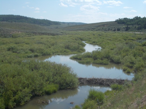 |
| Beaver dam! |
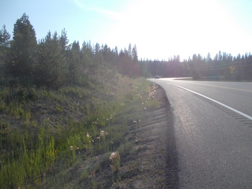 |
| The shoulder along Highway 40 was much wider and therefore more comfortable to walk, but the traffic was even busier than it was on Highway 14. |


No comments:
Post a Comment