 |
| Mural on the Eureka public library |
My first stop was the post office where I mailed my laptop ahead. It wouldn't fit in my pack--the giant, hulking thing, so I carried it the mile or two into Eureka's main post office which was uncomfortable and a pain.
Out of Eureka, the trail followed a nice route along the Tobacco River for several miles. It was flat, fast and easy and, except for the soaring temperatures, a nice section to walk.
As the trail approached the podunk known as Rexford, the trail followed gravel roads, which intersected with a lot of other gravel roads and I had severe trouble figuring out which way the trail went. The trail wasn't marked in any way, my map wasn't detailed enough and even my GPS led to a road with posted signs warning that the road was "private property" and "do not enter." This was the trail? Or did it just refer to vehicular traffic? I'm not really inclined to deliberately trespass onto private property, though, and decided to find a way around it.
 |
| Still a lot of wasps buzzing around! |
Early in the afternoon, I finally arrived at a beach with clean water, restrooms and picnic tables. Even better, the picnic tables were in the shade. The restrooms, I swear, were the nicest, cleanest public restrooms I had ever seen! I decided to stop for a three hour break to beat the heat of the day. I'd continue later in the afternoon when, hopefully, it would be cooler with a plan to reach camp just before sunset.
I laid out on the picnic table for a bit and ate snacks, but most of the time I spent reading my Kindle.
After three hours, it was now 4:00. Still miserably hot--actually the hottest time of day in these parts--but temperatures would only cool from here on out. I'd have preferred waiting another hour or two for temperatures to cool but I wouldn't make it to camp before sunset if I did that. The rest of the day would largely be a road walk along a busy highway and I wouldn't have many good camping options. Nope, I needed to get a move on.
I soon lost the trail--again. I'm not even sure the beach I was at was even on the official trail in the first place, but I followed some roads that eventually led past the Rexford post office (which was closed) and a restaurant that seemed to make up the entire downtown core. It also meant I was wildly off track because the official trail on my map clearly showed the trail closer to the shoreline and missing downtown Rexford. At least I could confirm I had taken some wrong turns!
 |
| I knew I had definitely taken a wrong turn when I ended up at the Frontier Bar in Rexford! |
At that point, the day's hike turned absolutely brutal. The highway provided absolutely zero shade from the blistering heat, it was a relatively busy road with fast-moving vehicles and was paved with heat-absorbing asphalt. And I had to follow it for nearly seven miserable miles.
It was horrible! Okropne! Masakra!
Halfway through the road walk, two bicyclists caught up with me and slowed down to my walking speed to chat for about 5 minutes. They introduced themselves as Chris and Ryan. (Hey! I'm Ryan too!) They had started bicycling from New York and had been on the road for 5 weeks now, heading toward Anacortes in Washington. "Hey, so am I!" I exclaimed. "What a coincidence!" Of course, Anacortes wouldn't be the end of my hike--no, I planned to keep going all the way to the Pacific Ocean. Ryan offered me a beer which I turned down because I just don't like beer, but out of curiosity I asked him how he kept it cool in this heat. Did he carry it in a small ice chest with dry ice or something?
 |
| Chris and Ryan leave me in the dust! |
My water had warmed to the ambient 91 degree temperature outside and tasted like crap. The spigot at the beech provided nice, cold water and I drank a lot of it during my three-hour break, but after filling up with water and heading out, it quickly warmed to outside temperatures and now tasted absolutely awful.
But no, he said, the beer was hot. Usually he didn't have any during the bike ride and would stay with locals along the route. There's a network of places that bikers who tour this route can often stay at which is what they did most of the time. Civilization and cold beers almost every evening. Made me a little envious and wistful!
But they had a schedule to keep and eventually continued on without me. I think they were curious about the strange creature they saw actually walking the road that they were bicycling. I don't think they had seen many hikers along their route.
Near the end of the highway walk, the road passed over a creek on a bridge and I ducked under the bridge to get cool water from the creek. The bridge also provided a good bit of shade finally allowing me to get out from under the brutal sun. Temperatures had already started cooling by this point, but it was still miserably hot and the shade and cool water were a welcome treat. The water, much to my disappointment, wasn't actually cold. Just cool. It if were deeper, it might have been a nice place for a swim.
 |
| I took a half hour rest beating the heat of the day under this bridge and drinking the cool (but not cold) water from the creek flowing under it. |
I took a half hour rest here since it was unlikely I'd find anywhere else that would be as pleasant for a break. It was tempting to camp here for the night--there was plenty of space under the bridge--but I really wanted to get through this road walk so I picked up my pack and pushed onward.
Finally I reached an intersection at one end of the bridge crossing Lake Koocanusa. The lake was enormous stretching for something like 100 miles. So long, it even backed up into Canada. (The name of the lake even has "can" in it--short for Canada--and "usa" in it to represent the USA.) This bridge was the only place to cross the lake. It was a man-made lake created in the 1970s with the construction of a large dam downriver. The bridge was also touted as the longest and highest bridge in Montana.
It was a substantial bridge, but I wasn't terribly impressed with either its length or its height, but an informational board at the intersection showed photos of the bridge before the lake had filled with water and in that photo, the height of the bridge looked dizzying high! The part of the bridge sticking out above the water was actually quite small compared to the total height of the bridge. I had no idea that the lake so deep!
Crossing the bridge got me off Highway 37 and its relatively busy traffic. The far side was still a paved road but much quieter. And shaded! The sun had descended far enough so the mountains lining the lake cast long shadows casting the entire west side of the lake in shade. It was positively pleasant to walk again! Except for the asphalt, of course.
I had to hike just over a mile along this road before the PNT veered off into the woods and up a steep mountain. That was my goal for the day--to reach that trailhead. My guidebook said there was a campsite about 10 minutes up the trail and I pushed onward to it. Camping in the woods would be infinitely more comfortable than camping at the trailhead!
And finally, I arrived in camp at about 9:00pm. It didn't leave me with much daylight to set up camp, cook dinner and get ready for bed and the last bit of dinner I ate in the dark.
 |
| The longest and highest bridge in Montana! |
 |
| A giant, oversized fishing pole in the riverside park in Eureka seems to suggest that fishing might be a popular pastime in the area. |
 |
| The trail out of Eureka followed alongside railroad tracks on one side... |
 |
| ...and the Tobacco River on the other side. |

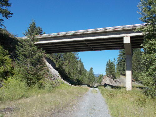 |
| Here the old rail trail passes under Highway 37. |

 |
| Lake Koocanusa |
 |
| I know somewhere you can buy firewood in Rexford.... |

 |
| Still Lake Koocanusa--as far as the eye can see! |

 |
| The long, miserable road walk.... |
 |
| See the bridge crossing the lake far in the distance? That's where I'm heading! |
 |
| And here it is! Montana's longest, highest bridge! |
 |
| I looked down, but it didn't seem that high. I didn't realize how deep the water was, though! |
 |
| I hoped this roadside memorial wasn't a previous PNT thru-hiker! |


2 comments:
The memorial is from a 1997 boating accident with 3 deaths. That memorial was removed in October 2019 after 22 years.
https://flatheadbeacon.com/2019/10/02/families-men-killed-1997-boat-wreck-upset-forest-service-removes-memorial/
Okropne & masakra, huh? ;-o)
Post a Comment