Showing posts with label blowdowns. Show all posts

Wednesday, June 15, 2022

Day 106: Cirque of the Towers

August 4: I was up and hiking by 6:30am. The morning was surprisingly chilly and condensation was a small issue, but I still found it surprising how dark it was so late in the morning. At least it gave me more time to sleep in during the mornings.

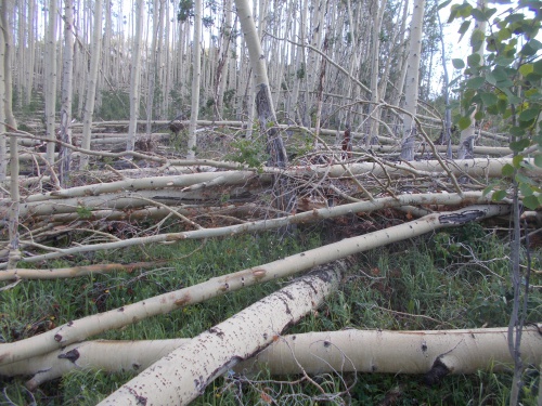
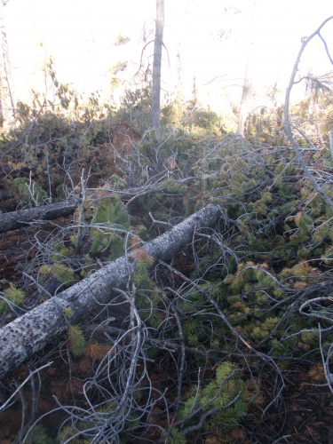
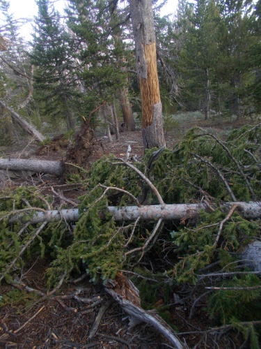
It wasn't long before I reached the Bad Blowdowns. Hundreds of fallen trees had fallen over, and my progress slowed to a crawl as I bushwhacked around and through them. It didn't take long before I lost the trail completely and just had to follow my GPS tracks.

Today, the blowdowns would be bad. Very, very bad, and it was just beginning!
 

Almost immediately, I ran into two other CDT hikers, a couple of south-bounders! They said they were from Switzerland so I wished them a good morning in Swiss-German ("Gwita morka!") and compared trail notes.

I assured them that they were almost out of the really bad blowdowns, but they assured me of the complete opposite--I still had a long way to go. They had come up from the Cirque of the Towers alternate, and cut the corner where the CDT normally intersects with the alternate. 

This was the same alternate that the hiker I met in Rawlins made me swear to take before he let go of me, and I had every intention of doing just that. By all accounts, the main red-line route was essentially impassible. One Guthook comment I read left by a south-bounder was pretty amusing. He'd read the comments from the north-bounders and figured we didn't really "know" what we were talking about. They had seen some pretty bad blowdowns in Montana and figured this couldn't be any worse than they had in Montana, but this south-bounder who tried it anyhow admitted to being "humbled" and urged his fellow south-bounders not to dismiss the warnings. They were real. It was bad. It would rip up your legs and could take you all day to go 5 miles. It was dangerous and to be avoided, and he had learned his lesson the hard way, but that they could learn from his mistakes.

However... the alternate didn't avoid all of the bad blowdowns. I was still in the middle of it, after all. But some hikers had noticed the alternate intersects with the CDT at a right angle, and it was possible just to bushwhack cross-country between the two trails making the overall route a bit shorter. The blowdowns were still bad, but there was less that would have to be traversed. And my new Swiss friends informed me that someone had actually set up small, rock cairns along this alternate of the alternate. They were only a few inches tall, however, so you really had to keep your eyes open for them and they'd help get around the worst of the blowdowns.

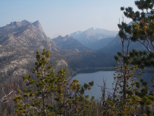
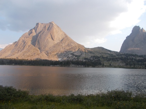
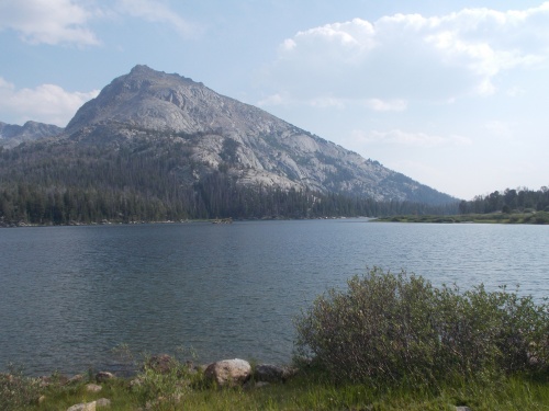
The trail for the Cirque of the Towers alternate was along the left side of that lake. And in this case, the best way to it was directly down this mountain and cross-country through the trees.
 

So we parted ways, and I started following the small cairns down a steep hillside filled with blowdowns. Through gaps in the trees, I could see a lake near the bottom of a valley, and I knew the Cirque of the Towers trail passed by the left side of it, so I just had to aim toward the lake.

It probably took me over an hour, but I finally reached the edge of the lake and largely got out of the blowdowns. I still needed to bushwhack a bit around the edge of the lake to the other side then find the trail there, but I was able to move a little faster now. Just a little, though. You can't go fast where there is no trail.

There were some muddy areas with stagnant water that I had to get around, and I had to backtrack a couple of times when I followed social trails to dead ends where found myself surrounded with impossible-to-pass boulders, but eventually I made it around and found the actual trail again. It was a time to rejoice! The worst was finally behind me!

Or so I thought....

Once I hit the bottom of the valley, the blowdowns largely stopped and the route became a bit easier.
 

I took a break near a creek at around lunchtime. Ate some food, rested, and I rinsed my socks with the creek water. I didn't wash my socks--I never do that on the trail--but my socks had been feeling sticky and gross and I figured a good rinse would do them well. They were wet afterwards, but it felt like pure bliss after that. What a different just a rinse can do. I went ahead and soaked my feet in the creek as well since my socks were going to be wet anyhow.

The trail largely followed a pretty creek upstream. At first it was easy going, heading steadily uphill, but continued to grow steeper and steeper the further I went, eventually crossing over a big pass before the trail crashed steeply downhill into the next valley.

Later in the afternoon, I passed another south-bound CDT hiker. Three in one day! They were getting thick now! We stopped to chat for a few minutes. Mostly, she had concerns about how the trail looked up ahead after hearing all the same horror stories that I had, and I told her that yes, it was as bad as described, but fortunately the really bad stuff was pretty short if she took the same cutoff by the lake that I did and followed the little cairns.

Her name was Sprout--the third Spout I'd now met on the CDT. Then she told me that she was running a bit low on food, having only a day's worth left, and was trying to make it to the next town before she ran out completely. I wasn't sure she'd be able to make it to town in just one day. It might be possible, but it would be a challenge. I did, however, have plenty of food and even a little extra and offered to give her some.

For some reason I still don't quite understand, I had grabbed a package of mashed potatoes from the hiker box in South Pass City which I didn't really need. I think I grabbed it under the theory that it was better to have too much food than not enough, but now that the really bad section of blowdowns was behind me, I was less concerned about the extra food and heavy weight. And I also had an extra bag of Skittles that I really didn't need. Between the two, I probably lightened my load by a whole pound, which pleased me greatly.

Sprout seemed a little concerned. "Are you sure you don't need this?" 

"Definitely!" I assured her. "You'd be doing me a favor and lightening my load by taking them off my hands. I have plenty of food still to get me to the next town."

Then we continued on our separate ways.

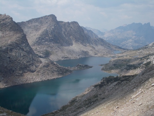
This alternate route was truly spectacular! Difficult, but spectacular!
 

Near Big Sandy Lake, the trail must have approached near a trailhead because the number of weekend backpackers absolutely exploded! It seemed like there were hundreds of people around, but it probably was no more than a few dozen. By my standards, however, it felt pretty crowded.

At one intersection, I noticed a woman coming up a side trail. She had a total thru-hiker look about her: an extremely small and light pack, seemingly hiking alone and wearing a short skirt which didn't seem like the traditional gear most weekenders would wear or could be purchased at an REI. The only reason I had my doubts if she was a thru-hiker was the fact that she was coming in from the wrong direction. A north-bounder like me would be coming up from behind me on the trail, and a south-bounder would have been coming toward me from the trail on the right, not the one on the left that she was following. Unless, perhaps, she had taken a wrong turn and was returning to the trail?

I wasn't sure, but I didn't worry about it too much either way. When she reached the trail, she turned north-bound on the CDT, the same direction I was heading, and we passed each other a couple of times as we both ascended the steep climb over Jackass Pass. She complained about being winded from the altitude. I complained about being winded because it was hard. =) But she flew over the trail much faster than I was hiking, but I would catch up when she stopped to chat with others we would pass on the trail.


Eventually, we started chatting with each other and she introduced herself as Little Red Riding Hood. She was not, in fact, thru-hiking the CDT, but my gut feeling about her being a thru-hiker held true in the sense that she had thru-hiked the PCT before. She had a thru-hiker look because she was a thru-hiker--just not currently thru-hiking. She had taken a few weeks off work to do a little backpacking, however, and wanted to go somewhere where there would be thru-hikers and heard this area of the CDT was pretty amazing.

She also had what sounded like a British accent so I asked where she was from. I was more than a little surprised when she told me Seattle.

"No way! So am I!"

So then we talked about Seattle a bit. =) I did ask about the accent, curious about how she ended up in Seattle, and she had spent a great deal of time in the United Kingdom. I don't remember all the nitty gritty details, but as I recall, I think she had some sort of duel citizenship, perhaps because one of her parents was American? I'm not really entirely sure about that, however, so don't quote me. She said that in England, however, they think she has an American accent. I guess her accent lies somewhere between the two, which seemed fitting given her situation.

Anyhow, we continued on at our own paces, and eventually she out-distanced me.

I finally made it up to the top of Jackass Pass--I love the name of that pass, btw. I might use it more often than is strictly necessary. ;o)

Jackass Pass, the name is real! I swear I didn't make it up! The climb up is a pain-in-the-jackass, though.
 

And found it a little disheartening to see the trail descend so steeply back down toward Lonesome Lake--which was anything but Lonesome. Signs said that camping within 1/4 mile of the lake shore was prohibited, but that didn't stop seemingly a hundred people from camping just outside that limit. And this time, it was not exaggeration. I didn't count all of the people in all of the campsites that I passed, but it would not surprise me if they numbered over a hundred.

Two people I passed told me that they were guides for a NOLS course and that there were NOLS participants all over the area. Last I had heard from Evenstar, she was taking a NOLS course and was heading to somewhere in Wyoming and on portions of the CDT. Once the course started, her cell phone was taken away. Against the rules (or something), so I hadn't gotten any updates for a couple of weeks, but it was quite likely that Evenstar was somewhere in the area so I tried searching the faces of all the groups I passed. 

I never did find her--it was kind of a long-shot anyhow--but she did text me later that she had run into a few CDT hikers during her NOLS course that she knew from earlier on the trail. Just not me!

I was hoping to camp with Little Red Riding Hood for some company in the morning. I figured she was probably camped somewhere around Lonesome Lake, but I never spotted her. Probably camped far enough off trail that I couldn't see her. Oh, well. Another night by myself wasn't the end of the world.

The hoards of people camped near the lake did bother me, however, so I followed the trail to the far side of the lake hoping it would be less crowded. Unfortunately, however, there weren't any campsites available that were a quarter-mile away from the shoreline. I really did want to follow the rules!

Lonesome Lake

So I kept following the trail where it left the lake, heading up toward another high, steep pass. I did not go far, however, before I found a small space between a tree and a boulder where I thought I could fit. I wasn't strictly certain that I was at least one-quarter mile from the shoreline, but it was probably close. I feared, however, if I kept going further, I might not find anywhere else available to camp. The hillside was just so darned steep! The only reason this tiny piece of ground was so flat was because it was behind a boulder that seemed to prevent erosion above it that caused it to level out, but the space was maybe six feet long and a few feet wide--about the size of a coffin, actually. I could make it work, though.

No rain was expected during the night so I didn't have to worry about setting up my tarp, and the branches of a large tree hung over the site which would probably protect me from condensation in the morning. It was a bit cramped, but it would do.

My goal for the day had been to do 20 miles, but I failed. I pulled a measly 18.1 miles according to my GPS, but I was completely exhausted and set up camp perhaps a half-hour before sunset. It was a tough day. Not just because it started off with all those blowdowns, but the terrain was far more rugged than I had anticipated. The steep ups and down and ups and downs. This alternate was listed on Guthook, but it didn't show the elevation profile of the trail so I hadn't realized how rugged the terrain really was. 

When I checked my GPS, I was astonished to see it had recorded about 5,000 feet of elevation gain and another 4,000 feet of downhill travel. That's a lot of elevation change in a single day. *nodding* And only in 18 miles, no less! But at long last, my day was finally over, and I was so ready for it to be over.

After sunset, I could see the headlamps of all the hikers camped on the other side of Lonesome Lake. Kind of like fireflies from my point of view as their headlamps flickers through the trees. =)

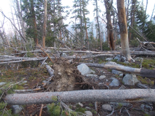
I'll share a few more photos of the blowdowns in the morning to give you a sense of what it was like, but in the really worst areas, I needed both hands available to climb over and around the blowdowns which meant that I couldn't get photos. I could only get photos of the "easy" blowdowns!


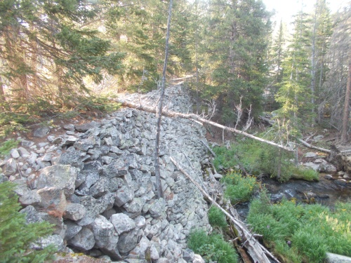
I'm not sure what this dam was doing here, but it made a convenient place for me to cross the river coming out of the lake.


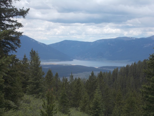
Such gorgeous views! I absolutely loved them! But dang, this trail is tough!


Big Sandy Lake


Wednesday, March 23, 2022

Day 70: More blowdowns!

June 29: It rained on-and-off during the night, but it never gave me any trouble. I stayed warm and dry under my tarp, and got a decent 6:30am start on the trail.

I figured there was a good chance I'd see Skunkbear who I knew camped somewhere not far ahead, but I never saw her. I'm not sure if she left even earlier in the day than I did or if she camped so far off trail that I didn't see her, but the result was the same either way.

Blowdowns were my biggest problem in the morning, but this section at the edge of a meadow wasn't super bad. Aspen trees were a lot easier to climb over than the pine trees!

Within a mile or two, I hit another set of severe blowdowns. I knew it was coming. The Guthook comments had all sorts of comments about them, so it wasn't a surprise, but it was still disappointing. The section of trail with the blowdowns didn't just have a lot of blowdowns, but it was as if a logging company came through and clearcut the area leaving behind a massive jumbled pile of logs. Some sections, quite literally, had no trees left standing at all! Often piled as high as my chest.

The Guthook comments from earlier hikers suggested heading off trail to a meadow a bit to the east, then following the meadow to its end since the meadow would largely be clear of blowdowns. Can't blow down trees that were never there, after all! From the trail, I could see even see the meadow over the blowdowns, and I scrambled over to it. It was an excellent idea!

The meadow wasn't entirely clear of trees, however, since many aspens along its edge had fallen into the meadow. It was, however, significantly easier to get through than the staying on the main trail would have been.

At the end of the meadow, I dived back into the thick blowdowns and struggled to get through. At times, it felt a bit dangerous, climbing up onto a big log and jumping from one to the other. I was a little disappointed that I hadn't found Skunkbear and could go through with her in case I misjudged my footing or something. Or even to help look for a better route through this mess. Sometimes, four eyes were better two. Actually, for all I knew, she could be in this mess at this exact moment, but we had taken different routes through it. Oh, well.

There's a trail somewhere on the other side of these blowdowns....

I continued onward, going under and over trees. I couldn't go around them, though--that was never an option. There were always more blowdowns no matter how far I tried to swing around them.

Fortunately, the really bad area didn't last long, and I soon descended a steep slope that reached the trail. And, even better, the trail had been cleared of blowdowns already! A trail crew had been up here to work on the blowdowns. They had probably been out several times given the sheer volume of blowdowns that needed to be dealt with, but they hadn't finished clearing the entire length of the trail. They had, however, finished clearing it up to this point, so once I got back on the trail again, it was clear sailing!

Love trail workers! They make these hikes possible. *nodding*

Another mile or so down the trail, I heard voices. They were faint and sounded off trail. I stopped momentarily to hear them better and found a couple of people crossing a creek off to my right, complaining bitterly about the blowdowns and having lost the trail.

I called out to them. "The trail is over here!" I shouted.

"You're on the trail?" they asked.

"Yep!"

They bushwhacked over to me, excited to be on real trail again. They too had taken the meadow through the blowdown but never managed to find the trail, bushwhacking a whole mile down to this point where I found and "rescued" them. They were a couple of locals who had gone out for a couple of days, but one of them had to be at school or work or something later that morning and was afraid that he wouldn't make it back home in time. Now that they were back on a real trail, they had a chance!

I just love these flowers! So pretty....

We soon reached the trailhead, and they asked if I needed a ride into town. It was possible to hitch into Buena Vista, and some hikers certainly did do that. (Evenstar, I would later find out, did precisely this.) I had carried enough food to get me to Leadville, however, and wasn't looking for a ride into town. A bit of a shame, though, to not take a ride offered to me right there at the trailhead.

Once I passed the highway, the trail headed steeply downhill toward Texas Lakes, where it started sprinkling ever-so-lightly. When I went to pull out my umbrella, I was shocked and horrified to discover that it was missing! It must have fallen out of my pack while scrambling through all those blowdowns in the morning. Noooo! I can't live on the trail without an umbrella! That's practically one of the 10 essentials!

I definitely wasn't going to go back to look for it. Even if I did, the chances of finding it among all those blowdowns would have been almost zero. I couldn't have retraced my route through that mess to save my life. The umbrella was gone forever. *sigh*

With a heavy heart, I pushed onward. But I did text Evenstar, who was behind me, to look for my umbrella among the blowdowns if she went that way. =) (She never found it, though.)

One of a string of lakes known as the Texas Lakes.

At the Texas Creek trailhead, I was at the end of the Mirror Lake Alternate and back on the main red-line CDT. I wondered if Reality Check, Cramps, and Outlaw had already passed by this point or if I somehow got ahead of them. The distance between the alternate and red-line CDT were about the same, so it's not like I took a shortcut. But at the same time, if they had severe weather on the mountain ridge or slept in later than I did, it could have slowed them down. I figured they were probably ahead of me since they all hiked faster than I did and likely didn't stop to camp as early as I did last night, but I couldn't know for certain.

Without a doubt, however, they were nearby. Maybe ahead of me, maybe behind me, but there was no way to be sure. Just like Skunkbear. It was a little weird knowing that there were all sorts of hikers nearby but not knowing if they were ahead or behind me!

From the Texas Creek trailhead, the trail climbed steeply uphill to a pass before another long downhill. Nobody ever accused Colorado of being flat!

At the top of the pass, I noticed a solitary hiker behind me on the trail. I couldn't identify who it was, however. Just a speck on the trail in the distance. It might not have even been one of the hikers who I knew was somewhere nearby on the trail, but it could have been someone else entirely. Nope, I'd just have to find out who it was when they got closer. 

Looking back toward Texas Lakes

Along the way, a total of 8 motorbikes passed me, tearing up the trail. Literally tearing up the trail. I could see the dirt flying off their tires like shovels, and the loud noise was a huge annoyance. I think it was probably legal for them to be there, but I still didn't like it. It definitely detracted from the otherwise wilderness experience. 

Late in the day, I set up camp near a creek. Nice and quiet. No real rain had materialized during the day--and thank goodness for that since I no longer had an umbrella!--but it was forecasted for the night so I set up my tarp.

The mysterious hiker behind me never caught up, so I never found out who that was. Perhaps it wasn't even a CDT hiker and they had turned off onto another trail before reaching me? No idea! And perhaps I'll never find out....


It's always a great feeling to reach the top of a pass. The exhausting uphill is done! Time for a little downhill now! =)


Friday, December 6, 2019

Day 18: Battle With the Blowdowns

August 2: I woke up and--as quietly as possible--ate breakfast and packed up gear. Ryan was still sleeping on the floor of my room and I didn't want to disturb him any more than was necessary. Just before leaving, Ryan was awake and I gave him the room key saying that he was welcome to stay until checkout although I wasn't exactly sure when checkout time was. Probably 10:00 or 11:00--those are usually the standard checkout times.

I left the room just before 8:30am--the time I had arranged for Gypsy to pick me up. I would have preferred to leave earlier and get in as much hiking when the temperatures were cooler in the morning but I still needed to mail my laptop ahead to the next town and the post office didn't open until 8:30.
I couldn't leave town before 8:30--that's when the post office opened and I could mail my laptop head.

Gypsy was already there when I came out and I hopped into his vehicle and off we went. The first stop was at the downtown post office which was opening just as I arrived. I mailed my laptop ahead then it was time to hit the trail!

Gypsy wanted to take a scenic route to the trailhead where he had first picked me up two days earlier that wound up following some gravel roads. At one point, we saw a gorgeous bald eagle sitting at the top of a tree alongside a river as if waiting for a fish to show itself. Gyspy told me about a fisherman he saw a couple of days earlier that would catch a fish and throw it into the air and an eagle would swoop down from overhead to grab it. It sounded really cool and I wished I could have seen the scene.

The scenic route took about an hour longer to get to the trailhead than the direct route, and while I enjoyed the conversation with Gypsy, I was anxious to get on the trail and get hiking. I was a little disappointed it took so long. Gypsy didn't realize it would take as long as it did either. It was still faster than walking, though! And probably faster than trying to hitch a ride! =)

This is Gypsy!

Eventually we reached the trailhead. Gypsy offered to drive me up past the road walk section, but I turned him down. Yeah, it was just a stupid road walk, but it was part of the trail and I was going to walk it.

We shook hands, took some photos, and I headed off up Highway 1. The first 8 miles of the day would be a road walk on mostly paved roads and temperatures were becoming uncomfortably warm. The forecast later in the week had temperatures hitting 100 degrees in Bonners Ferry, but they'd be in the 90s until then.

There was also almost no shade at all during the road walk as it passed through farm country. Except for that short section on Highway 1, though, at least the roads weren't busy with a lot of traffic.

An hour into my hike, a young girl driving a small buggy pulled up next to me asking if I was hiking the Pacific Northwest Trail.

"As a matter of fact, yes...."

Her name was Jess, if I remember correctly, and she lived in a farmhouse just up the road and saw me walking down the trail and jumped into the vehicle to chase me down. She liked having hikers sign her register (I was the 18th for the year--if I remember correctly?) and she offered me a cold half-liter bottle of kiwi-strawberry flavored water which I was happy to take. She asked about any other hikers who might be behind me and I told her about Ryan who would likely pass by later in the afternoon unless he decided to take a zero day in Bonners Ferry in which case he'd likely be passing through tomorrow morning.

This is Jess, who hunted me down on the trail to sign her hiker register and to give me a cold 1/2-liter bottle of kiwi-strawberry flavored water. (Those mountains in the background are the ones I'd have to scale later in the day.)
We talked about the trail a bit and I tried to convince her to do a part of it someday. Start in "Glacier NP and walk home!" I exclaimed. That would be cool. She could literally walk home! She didn't seem too interested in actually hiking the trail herself but seemed fascinated by the people who did. Then she told me about a trash can ahead where I could throw out the bottle and any other trash I had--then she was off, and I continued my walk.

I passed by a guy who was working on some farm equipment and he greeted me warmly and asked something about if his daughter had treated me well. "Yes, very friendly!" I replied. =)

I continued walking and a half hour later the father whose name I never got drove by on his way somewhere. He stopped briefly asking if I'd like a ride to the end of the road walk--apparently a lot of hikers take him up on the offer although many (including myself) did not. Nope, I wanted to walk the whole distance. No skipping sections--not even road walks!

He continued on in his truck and I continued onward on foot. At the far end of the valley, the trail reached the edge of the farmland and followed along a tree-lined road providing a lot more shade than before. The shade was a welcome relief.

Just before the road walk ended, the trail passed Parker Creek and the last good, reliable water source for 16 miles. I took a long, two-hour break by the creek waiting until the heat of the day died down a bit before the long 4,000-ft climb up Parker Mountain. I also cooked dinner now while I had plenty of water available.

It was here when I realized I had made a horrible, horrible mistake.... In my haste to leave Bonners Ferry, I had left all my cheese in the min-fridge at the hotel. Shoot! Argh! How was I going to survive without cheese?! I had purchased three packets of individually wrapped cheeses (I only meant to get two but ended up with three by accident)--and now I had none of it! I hoped Ryan found it before he left so it didn't all go to waste.

I took a two-hour break by Parker Creek--just before the big climb back into the mountains.

After the rest, I started the long slog up Parker Creek Trail. It was steep and relentless. A few blowdowns blocked the route but I navigated over, under and around them without too much trouble.

Pushing onward, I was mostly in shade which was a welcome treat on an otherwise miserably hot day. The slope I was climbing was an east-facing slope and late in the day with the sun moving toward sunset in the west, then east slope was almost entirely in shade.

An hour into the hike up, however, the trail reached an old burn area and took a severe turn for the worse. Thick pockets of blowdowns started blocking the trail. Not just a tree here and there, but dozens of them, piled and twisted together forming impenetrable masses of burnt wood. One early section took me five minutes to get around and I thought I was home free before the trail turned a corner and there was another impenetrable mass. Argh!

The blowdowns in the burn area were awful!

It was an utter nightmare! I couldn't possibly count the number of blowdowns blocking the trail, but they undoubtedly numbered in the hundreds. Maybe even into the thousands for all I knew. At times, I could look around and see hundreds of trees that had toppled like grass after being inundated by a nearby flooded creek. The fallen trees were so thick, I sometimes lost the trail completely.

At times, there was literally no way to get around the fallen trees and I scrambled over them--a positively dangerous activity. One slip or fall and you could impale yourself on a broken limb or find your leg plunging into a hole in the trees breaking it.

I had a couple of close calls.

One of them, I fell head first into a jumble of fallen logs and reached out my hand to prevent my head or eye sockets from being impaled by broken branches and it tore up my hand pretty well. Another time I fell back and I was like the proverbial turtle on its back. I couldn't get up or flip over without unbuckling my backpack and taking it off first.

Fortunately, this was the worst injury I suffered. It could have been a lot worse, though!
Another snag caught my pants and tore a giant hole in it and branches continued to scrape and rip at my clothes.

It was terrible. Absolutely god-awful terrible. One of the worst sections of trail I had ever suffered. I looked for anything that might shorten the horror. The trail had switchbacks back and forth up the mountain and I tried cutting switchbacks. I still had to climb over blowdowns, but it was a shorter path than following the switchbacks. At times, I was able to travel over a hundred feet without my feet touching actual ground the entire time.

I was glad I had my SPOT device with me. It was the first time on the hike where I felt that investing in a GPS device that could signal for help was definitely a good idea. I just had to make sure I could still activate it in case of a life-threatening injury. If I knocked myself unconscious or paralyzed myself with a broken back, it would be useless. If I had a hiking partner, at least one of us would still be able to signal for help. I really needed a hiking partner for sections like this--just for safety's sake. I wondered if Ryan was somewhere not far behind me.

At one point I finished scrambling over a mass of blowdowns and reached the actual tread of the trail again and I broke down and cried. I was absolutely miserable. At that moment, I wanted to quit the trail. I was lonely and definitely not having fun. And I felt this scrambling was positively dangerous.

Can you even see the trail under all those blowdowns?!

How much longer would these horrible blowdowns continue? Turning back was an option I considered, but I knew the horrors that were behind me. What if the worst was mostly behind me and the easiest way out now was ahead? I had no way of knowing so I continued pushing forward.

When I started up the Parker Creek Trail, I had a goal in mind--a campsite listed in my guidebook--but the blowdowns slowed me down dramatically. If I was making one mile per hour, I'd be surprised. I was probably doing a half-mile per hour. The sun started setting and I knew I wasn't going to make my goal for the night so I finally stopped at a section of the trail that was mostly barren of trees. There wasn't a lot of blowdowns only because there hadn't been many trees to begin with, and the area was a little breezy which helped keep the mosquitoes at bay.

But I wound up camping directly on the trail because there was just nowhere I could find that was flat enough and not covered with rocks and fallen trees to set up camp.

The view from my camp was nice. I could see far up and down the valley I had trekked across this morning. I imagined Jess and her family sitting down for dinner and her telling stories about the strange hiker she saw passing by today. They were probably right down there in plain view. If they had a telescope, they could watch me wallowing in self-pity. I wondered if Ryan was out there, camped at the base of the Parker Creek Trail not having any idea about the horrors that he would soon be facing.

I had never felt so lonely or angry with a trail, but I was glad to have a break from the battle with the blowdowns. I wasn't sure how much more of the blowdowns would be further up the trail, but for today, I was done with them. They had won.

Back on Highway 1, the road walk that started the day.


Kootenai River
The valley around the Kootenai River is lots of farmland, but the trail will head into the mountains in the distance.

At the edge of the farms, this road finally had a few trees to provide some much needed shade.
The first blowdown seemed like just a minor obstacle. Little did I realize the horror that was approaching....

Looking back at the farms I just walked through. The trail came down from the mountains on the other side of the valley, crossed the valley, then up the mountains I'm in now.
The blowdowns definitely numbered in the hundreds, but I wouldn't be at all surprised if more than a thousand of them blocked the trail. It's going to take a massive amount of work to clear this trail!

The view from my campsite of the Kootenai River valley was quite pleasant!