July 9: It was about 5:30am when I woke up. I laid around in my warm sleeping bag for a few minutes, then sat up rubbing the sleep out of my eyes and.... what did I behold? It was a moose! On the other side of the river, on the other side of a large meadow. It was probably the same moose I saw last night, but it was still too far away to get a decent photo. And the sun hadn't even risen yet, so the light was no better now than it was then. It seemed like an auspicious start to the morning, however, literally seeing a moose immediately upon sitting up in the morning!
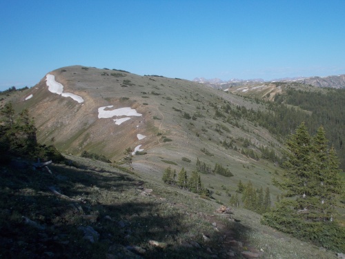 |
| Even the relatively "flat" ridge lines were deceptively steep and rugged! |
I soon lost sight of the moose behind some trees and continued with my usual morning routines: eating breakfast, brushing my teeth and packing up to hit the trail, and starting the day's hike at about 6:30. I would periodically look up to check if the moose had returned, but I never saw it again.
The trail out of camp immediately headed up a steep mountain, climbing thousands of feet and despite the early morning, it didn't take long before I was sweating bullets. My progress, however, was slow. The hillside was just so darned steep!
Above tree line, it was once again often difficult to follow the trail without a clearly defined path. I kept my eyes open for the cairns that marked the route and checked my GPS often. At the top of the ridge, the trail wasn't quite so steep, but it was along steep hillsides that I sometimes needed to use my hands to keep my balance, along with an occasional snow field that I had to loop around. My progress was remarkably slow. Despite my early start, I had only managed to complete about 9 miles by noon. Under normal conditions, I would have usually done about 12.
The ridge line that the trail followed went up and down and up and down. Never long ups or downs, but definitely steep ones, and one steep hillside I accidentally sent a jumble of rocks down. I thought it would level out here--on my maps, it looked pretty level. But the ups and downs were just too small to show up well, and I struggled along. Argh!
Eventually I reached a pass at which point the trail plunged thousands of feet into a deep valley, and for a few glorious miles, the trail was relatively flat and easy. Not the plunge down to the river valley, but rather following the riverside downstream. The trail was well-marked, easy-to-follow and relatively flat. And! I ran into another moose! Woah! This one was actually pretty close, maybe 30 feet from the trail, and I snapped a few photos with my camera that actually looked like a moose. They still weren't great photos, however, since he was hiding in the darkened shade of the trees and most of the time trees blocked my view, but the photos were still vastly better than the moose from my campsite this morning.
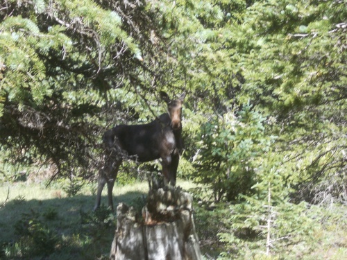 |
| My second moose of the day! They were everywhere! |
The easy section did not last long, however, as I eventually reached a gravel road and then had to follow it uphill thousands of feet to the crest. Again. Argh! At least the road was wide and easy to follow, but the climb up still winded me.
The trail led through a burn area that looked to be very recent, probably last year, before getting above tree line and reaching the crest of a ridge which happened to link up again with the main redline CDT. I was back on the main path! I hadn't seen a single other thru-hiker on the entire Silverthorne Alternate. I had also reconnected with the redline CDT after it split off from the Colorado Trail so I wouldn't be seeing the hoards of CT hikers anymore. Just other CDT hikers. (Not that I have a problem with CT hikers--I was one myself, once! But the last few days... there were just too many of them for my taste! Way too crowded!)
I'd been a bit lonely on the Silverthorne Alternate all by myself, though, so I was hoping to run into some CDT hikers now that I was back on the main route. As far as I knew, I was the only thru-hiker to take this particular alternate.
Within minutes, I passed another hiker with a dog heading SB on the CDT. We stopped to chat for a few minutes, and she was actually hiking to the Colorado Trail to thru-hike that. I joked that she missed the starting point outside of Denver, that she was actually on the CDT, but she knew that. She had started hiking from her home somewhere a little to the north and liked the idea of walking from the front door of her home to Durango.
The ridge crest was brutally windy, but I marched onward. Dark clouds had started blowing in my direction and I wanted to get off the ridge before they hit.
I didn't quite make it, though. Just before the trail plunged hundreds and hundreds of feet down the other side of the ridge, the storm started. Rain! Hail! Thunder! Boom!
It was the thunder that concerned me most. I was at the top of an exposed ridge.
 |
| Storm clouds rolling in |
So I didn't stop for any breaks at the top. I followed the trail to a junction, then down the side of the ridge as I was pelted to with hail. My umbrella was useless with the strong winds, so I did stop just long enough to put on a raincoat and gloves. My hands were absolutely freezing in the wind and rain.
Once I had descended several hundred feet and reached the protective cover of trees, I slowed down a bit and took my time. I was exhausted. I felt like Colorado was kicking my ass!
Less than an hour after the storm hit, the skies cleared up a bit and even showed pockets of sun at times. Colorado weather.... it's just crazy. *shaking head*
Further down the trail, loud, industrial machinery buzzed in the distance, which grew increasingly louder with every step. I could hear it from miles away! Eventually I got close enough to see the structure making the racket. I couldn't tell for certain what it was, but if I had to guess, I thought it was part of a quarry. (I later found out I was right--it was part of the Henderson Molybdenum Mine.)
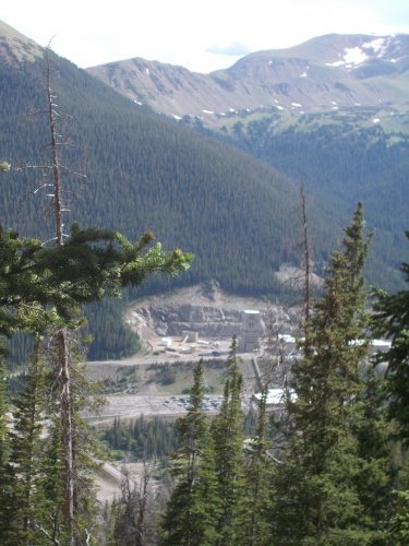 |
| The Henderson Mine was so loud that I could hear it for miles before reaching my closest approach to it at which point it was positively deafening! |
Later, I spotted what looked like a white fox running up the side of the mountain. Are there such things as white foxes in Colorado, though? I swear it looked very fox-like with it's long, bushy tail. I wasn't aware of any white foxes in the United States--well, maybe arctic foxes in Alaska? But I'd never heard of arctic foxes in Colorado! So maybe it was something else? I couldn't get a really good look at it since it was a ways up the hillside and quickly moving higher and away. Could it have been a pine martin? A white one? An albino? I didn't know. I felt lucky to have spotted it at all, but I really wished I knew what it was! I was able to watch it for about 10 full seconds as it scrambled higher up the slope and slinked out of view, but it was just too far away for me to really see it well.
Eventually I reached a small bare spot near a river crossing and I decided to call it quits for the day. It was only 5:30 in the afternoon, but I was absolutely exhausted. The trail had been brutal! I hadn't even made it 18 miles for the day, but my GPS had recorded about 5,400 feet of elevation gain and another 4,500 feet of elevation loss--nearly 10,000 feet of elevation change overall. And I couldn't even reach my intended goal of 20 miles for the day.
Anyhow, looking at my maps, I could see that the trail would soon rise up to the crest of another ridge, then follow along the exposed ridge for quite a number of miles. Given the strong wind and iffy weather, I preferred to stay where I was under the protective cover of trees.
I set up my tarp. More rain (and possible hail) was still in the forecast, after all. Then just laid around for a half hour enjoying the process of not moving!
 |
| I took this later in afternoon after setting up my tarp when it started hailing again. See?! It's a hail ball! |
It was maybe another hour or so later when another hiker arrived who introduced himself as IB Tat and asked if it was okay for him to join my campsite. "By all means! Come on in!"
He quickly set up his tent and except for a short conversation while he was setting up his tent, I didn't see or talk to him the rest of the night. He did tell me that he was a YouTuber, posting regular videos about the trail and basically edited them every night before going to sleep. Sounded horrible, really. Ugh. I can't even write these blog entries in real time and wait until after I finish my hike to start posting! Trying to post daily videos from the trail and editing them every night after a full day of hiking sounded pretty awful. Heck, I usually don't even want to write my journal entries every night and it's a struggle at times to make myself do that much!
If you're curious, his YouTube channel can be found at IB TAT. (Just be warned that he does use a lot of profanity in his videos.)
However! One thing he did tell me before diving into his tent to never be seen again was that Pez had been just behind him for much of the day and said that he probably wasn't more than a mile back. Awesome! So I hoped that meant Pez would arrive soon.
But, alas, Pez never showed up. He must have stopped to camp before reaching here. So close! Pez would have had no idea I was so close on the trail, though, since he had stayed on the redline CDT. I got ahead of him by taking the alternate, but he couldn't have known that.
Eventually the sun set and I drifted off to sleep to the humming sound of the molybdenum mine. There was nowhere in either direction on the trail for several miles where you could avoid the noise of the mine, but at least at this particular location it wasn't especially loud or obnoxious like along other parts of the trail where it was positively deafening!
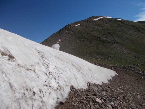 |
| Scrambling around these snow fields was often treacherous with all the loose rocks on the steep hillsides. |

 |
| Had to ford this river along the way. |

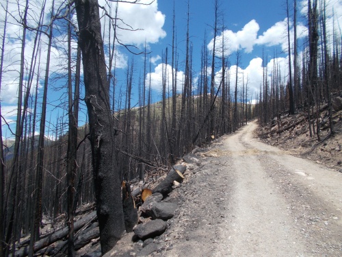 |
| This burn area looked very recent. I figured it probably happened last year. |
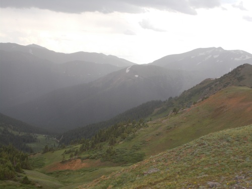
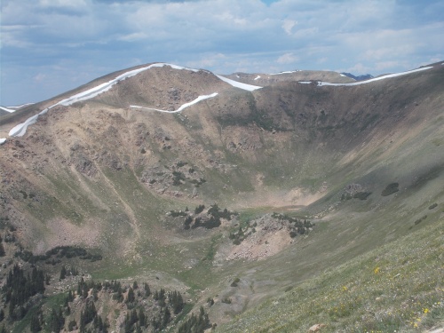 |
| The trail would reach the crest of this ridge then follow it to a point near the middle of this photo where the day's first storm would strike me. |


 |
| This tree was so inconsiderate, it didn't fall across the trail just once, but twice! Stupid trees.... |


