July 11: I woke up and hit the trail at my typical 6:30am start time. As early as that was, however, a set of three day-hikers passed by my campsite shortly before I got moving. They certainly had gotten an early start to the day!

It did not take me long, however, to catch up and pass them again. They were sucking in oxygen like it was in short supply. And, well, I guess it was considering the fact that we were heading up the highest peak of the CDT*! That little asterisk is because it would be my highest point of the CDT.
As I mentioned before, since I took the Silverthorne Alternate, I actually missed the "official" high point of the CDT. Nope, my high point was going to be James Peak which tops out at around 13,300 feet (4054 m) above sea level. But the air is still pretty thin at those altitudes, and these day hikers were sucking wind like crazy. I was a bit out of breath myself, but nowhere near as bad as they were!
From my campsite, the trail continued ever upward and upward. I had actually camped on the lower slopes of James Peak and the actual peak was only a few miles from my campsite, so I arrived at the top pretty early in the morning and had the peak to myself. Given how early those day hikers had passed me, however, I wondered how much more busy the peak would become later in the afternoon.
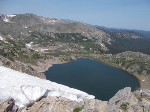
The views were awesome, blah, blah, blah. Really, there were awesome views from the top, but there are so many awesome views in Colorado, it's easy to grow used to them as being pretty average. =) I was actually more taken in by a still-frozen lake. It was mid-July! How can a lake still be frozen?! Even at these high altitudes, I would have expected it to have melted by now.
This also marked the point where Pez's alternate would have rejoined the red-line CDT. He was probably ahead of me somewhere, but if for some reason it took him longer than expected to hike the alternate, he could be behind me. Not likely, but possible....
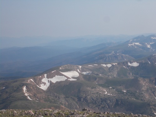 |
| Views from the top of James Peak were awesome! (Although still a bit hazy from smoke.) |
Anyhow, from the peak, I headed down the far side, a long, steep decent during which I passed a couple of more people out for the afternoon. Yep, I had a feeling that James Peak was a popular day-hike destination. Perhaps not as popular as Flores Peak, but still a busy one.
One group of people I passed included a former thru-hiker of the CDT, who introduced me to her hiking companion who was supposedly a popular trail angel.
"Cool!" I said, then joked, "What do you have for me?!" =)
They all laughed. He didn't have anything. He was just out for a hike today, but he gave me his contact information and said if I ever needed anything--don't hesitate to give him a call.
I joked: "And you call yourself a trail angel? Give a cold soda or something! Not a phone number!"
It's all good, though. I was just joking around. I certainly didn't expect any trail magic out here in the middle of nowhere. I'd have been more surprised if they had packed up an ice chest!
Anyhow, continuing onward, the trail eventually linked up with an old road. Well, technically, it largely followed the top of a ridge, but all of the comments in Guthook and even the day-hikers I met recommended following the gravel road instead. The views were just as good and the trail was in terrible shape--at least where there actually was a trail to follow. The road followed parallel to the trail, just below the top of the ridge.
So I followed the gravel road.
And it was enjoyable. Great views, easy walking. Good times! I could see the small town of Winter Park at the bottom of the valley a few miles away and therefore got excellent phone service pretty much the entire day.

The road eventually led to a trail, which then led to another gravel road and this gravel road was surprisingly busy with traffic! I soon ran into a group of ATVers and the lead guy stopped to ask if I was hiking the CDT.
"Well, yes I am!"
We chatted a bit, and he told me that there was a skiing competition going on a few more miles down the road.
I looked around at the surrounding terrain and the dwindling patches of snow.
"Did you say a skiing competition?" I asked, not sure I heard him right.
"Yeah."
I was still not sure I heard him right. "I thought there needed to be snow for a skiing competition. It's mid-July!"
"Yeah, I did too! It's not a very impressive course."
Hmm... Okay, this is interesting.
The ATVers went off to do their ATVing, and I continued walking down the road toward... a skiing competition, apparently.
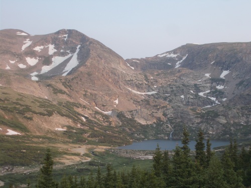
It was probably an hour later when I turned a corner and could see a line of vehicles parked on the side of the gravel road. Some people were sitting in lounge chairs near their car, focused on a small patch of snow on the other side of Corona Lake where several people could be seen working their way up a small patch of snow then skiing down.
I stopped to watch a bit, fascinated. As best as I could figure, the contestants were doing some practice runs down the snow. From top to bottom, it would take them all of about 10 seconds. It wasn't a very long course!
I wasn't sure when the actual competition was going to start. One guy I watched pulling skis out of his truck and throwing them over his shoulder and starting the hike (sans-snow) to the trail leading to Corona Lake. It was a little surreal...
 |
| That patch of snow down the side of the mountain and ending at Corona Lake was where the skiing competition was being held. You can see some small tiny dots along it--those are people participating in the event. |
Since there was a porta-potty for the event, I went ahead and used it because, hey, why not? This was an official event, after all, and apparently a place for the contestants and spectators to do their thing was a necessity. In all, I could see about a hundred people milling around the area, with most of them viewing the going-ons from the edge of the road.
I didn't have all day to sit around and watch, however, so after about 15 minutes, I picked up my pack and continued onward.
The gravel road continued to Rollins Pass, at which point I could get back on a solid trail again and leave the crowds behind me. I still came across a few day-hikers on the trail who weren't part of the skiing competition, but they were only a few of them--not the crowds of people I'd seen earlier.
The trail wasn't too notable, curving around a deep depression forming King Lake before climbing up and back down to Devils Thumb Pass, at which point the trail practically fell out from under me.
The trail dropped steeply toward Cabin Creek, which wasn't a problem, but I did have to slow down a bit to watch my footing. It would be easy to twist an ankle on such steep terrain.
But it was when the trail dived backed down below tree line that the nightmare really began--a massive blowdown of trees. I had heard about a "high wind event" in the area at some point had blown down tens of thousands of trees and hikers described unspeakable horrors about this section of trail.
And it was bad. Very bad.
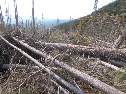 |
| Massive, head-high blowdowns along the trail definitely slowed me down! I had to follow the pink flagging (see it near the center of this photo?) because the trail itself was completely covered by all the blowdowns. |
The good news for me, however, was that trail crews had come out several times already this season to clear the trail. Their work wasn't done, but it took me maybe 20 minutes to cover a quarter-mile at which point I reached the work that the trail crews had completed and after that, the trail was in great shape.
But I could see the cut logs, often piled higher than my head, on both sides of the trail--a testament to the massive amount of work they had put it in clear so much already. It looked like most of the trail had already been cleared by the time I reached that point.
On the far side of the blowdowns, I found a sign warning that the trail beyond that point was "impassible." This, of course, was the direction I had come from. It definitely wasn't impassable--I just did pass through, after all--but I definitely wouldn't have recommended it to anyone! But now I could brag that I passed through an "impassible" obstacle. ;o)
I wound up setting up camp a few miles later, and almost immediately the mosquitoes started coming out and swarming. It was bad. I mean, I've seen worse... but it was bad. *nodding* Just awful....
I changed into my camp clothes and jumped into my sleeping bag to help escape them. They couldn't bite through my sleeping bag which protected most of my body, but I decided to pass on making dinner. That required me to expose my head and arms to the outside world and the mosquitoes were just too bad for that. I ate a few small snacks for dinner, then pulled the sleeping bag over my head and watched Netflix with my phone from under it. Ugh! Stupid mosquitoes. I really needed to get some equipment to help ward off those awful insects. I feared this was just the first of many nights that mosquitoes would be an issue....
 |
| Loch Lomond |
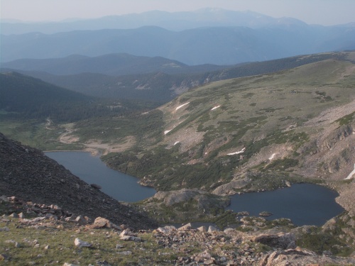 |
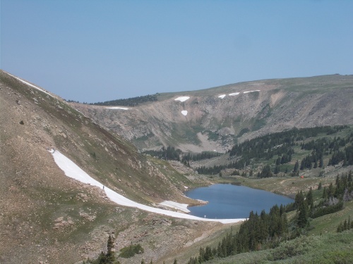
| This is looking back down toward Loch Lomond (the lake on the left) while climbing James Peak. |
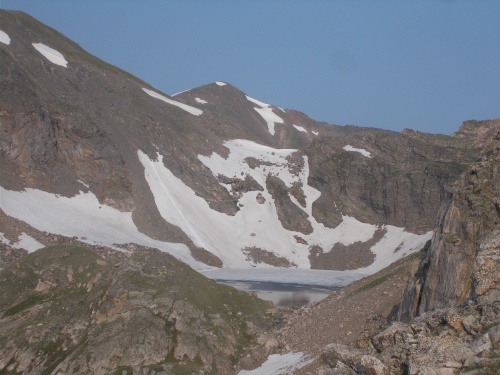 |
| And the highest lake of all was actually still frozen! I couldn't believe it! It's mid-July! |
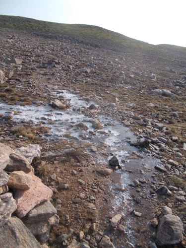 |
| Parts of the trail were frozen as well, but this probably just formed during the night when temperatures dropped. |


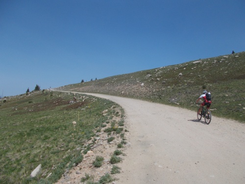 |
| As I neared the location of the skiing competition, I started seeing more vehicles and this mountain biker on the road. |
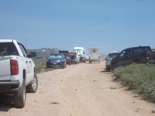 |
| If I had to guess, I'd estimate that there were maybe a hundred or so people around for the skiing competition! |
 |
| King Lake |


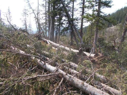 |
| Bad, blowdowns! Bad! |
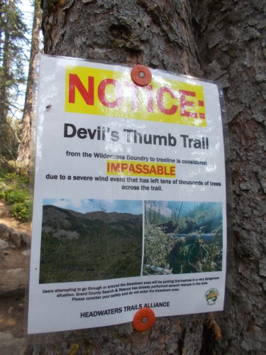 |
| It was impossible, they said. Impassable, even. But no... I made through. Because I'm that good. *nodding* =) |


No comments:
Post a Comment