Merry Christmas, everyone! I bet nobody reads this blog post today as y'all be out playing with your new toys, but just in case....one of you are still checking up on me, I'll post anyhow. =)
September 6: I woke up and hit the trail relatively early at 7:00am, again hoping to take advantage of the morning's low tides as much as possible. Krista was stirring when I left so we said goodbye to each other, and I wished her luck on future backpacking adventures. She seemed quite satisfied with her first night in the backcountry. Paul and Marshall were still asleep as far as I could tell so I didn't bother them on my way out.
 |
| Woke up to a cold and foggy morning |
The weather was dreary and foggy once again--seemingly a regular condition each morning on the coast. I hoped it would clear up later in the afternoon.
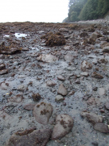
The trail out from the Chilean Memorial Camp passed around a difficult, rocky cape and the going was slow, but the other side of the cape turned into a simple and pleasant beach walk.
Until.... I reached the Norwegian Memorial Camp--another campsite dedicated to a shipwreck off shore eons ago. A Norwegian ship, no less! You'd think a Norwegian ship would have made a special point to avoid any location known as the "Norwegian Memorial" while sailing through the Graveyard of the Pacific....
But anyhow, the shoreline for the next four miles to Yellow Bank was absolutely awful. A rocky hell, difficult and slow to navigate. I can't say that I was surprised--my map warned that this section was particularly difficult and I had been dreading it for days. Because, shockingly, my map didn't warn about other difficult sections of the coast such as the area I passed through yesterday. If there was a special warning for this section, I thought, how much worse could this section possibly be than yesterday?!
As it turns out, I don't think it was anymore difficult than earlier sections, but it was still plenty difficult and the going was slow. My pace slowed to about 1 mile per hour at best, and hour after hour I struggled along the terrain.
I passed a few people heading in the other direction, proof positive that there was an end to the hellish terrain somewhere ahead. I joked with them about what they did to deserve being stranded out here.
A few hours into the section, I was navigating through some particularly deep seaweed, postholing through it, in fact, and watching my footing carefully when a loud crashing sound along the shore startled me. I looked up and saw a bear scrambling up the steep cliff. A bear! On the beach! I tried pulling out my camera, but it was too late. He had already scrambled up the cliff and into the trees. He couldn't have been more than about 15 feet away and I slapped myself for not noticing the bear sooner. He had been in plain view, but I was too busy looking at my feet and the seaweed and had been completely oblivious to the bear 15 feet ahead of me. It would have been a fabulous photo.
 |
| You can't see it, but there is a bear behind that tree! |
Happy to see a bear but disappointed not to have gotten a photo, I continued the march.
I finally arrived at Yellow Bank where a real sandy beach welcomed me. I felt so liberated from the rocky expanse I had spent the previous 5 hours navigating.
And... Yellow Bank was officially my campsite for the night. I was done for the day! Or... was I?
I had planned to finish the trail tomorrow, and Amanda had planned to pick me up. But she didn't want to just do a long drive to pick me up then a long drive back to Seattle. She wanted to make an adventure of it and had dreamed of hiking a triangular 9-mile route around Cape Alava that she had heard about years earlier, so she planned to drive out a couple of days early and do the loop herself. I hadn't been able to contact her since neither of our phones would get a signal in the wilderness out here, but... in theory, Amanda was supposed to be camped just a few miles further up the coast. If everything had gone according to plan, she should have camped at Sand Point last night then would be camped at Wedding Rocks tonight. Then we'd both hike out at the same point tomorrow.
It was still early enough in the day that I felt I could have made it to Wedding Rocks today, then I could catch up with Amanda and have that much less distance to hike out tomorrow. And I was a little worried about Amanda. I had seen the coast, and I knew it was difficult. And--my map warned of another particularly difficult section for those few miles between Sand Point and Cape Alava. Amanda, I knew, would not be enjoying this type of terrain. I wanted to catch up and make sure she was okay and help if I could.
And heaven forbid if she had to navigate one of those ropes up or down a cliff. I remembered one in particular I passed earlier that, when I saw it, my mouth dropped open in shock and I said--out loud: "Oh, hell no! What the f***?!" Fortunately, it was a low tide and I was able to walk around that headland without having to navigate those particular ropes. Some of them were positively insanely steep and crazy to do. I didn't even want to do them!
So I kind of wanted to keep going. Not just to help Amanda if she needed it--perhaps carry some of her gear since my pack was now nearly empty of food--but also so I had less ground to cover and could get done with this trail that much sooner. I was ready to be done!
But for the time being, I decided to take a lengthy rest. I was exhausted after covering this terrain and now the tide was quite high and blocking the route ahead. I could rest for two or three hours and make a decision then--but I was inclined to push onward.
So I threw out my groundsheet on the beach, kicked off my shoes, pulled out my Kindle, put on a jacket, and killed some time. The weather was still overcast and cold--perfect vampire weather.
My right foot was giving me trouble as well. When I took off my shoes and socks, it looked like the top of the toes of my right foot had a rash. I had no explanation for it and no idea how to treat it except to stop walking so much. It was more of an annoyance than anything, but it bugged me that there didn't seem to be anything I could do about it.
 |
| The top of the toes of my right foot were causing me trouble. |
About three hours later, it was do or die time. The tides were receding once again and the shoreline ahead should be passable. However, the sun still hadn't come out. And, in fact, it had grown even foggier than when I first arrived! Visibility was absolutely terrible. Fat droplets of fog hung in the air making everything feel wet. It had gotten so bad, I even set up my tarp on the beach to help keep dry while I was waiting.
And I eventually decided to stay put. The weather would likely still be foggy and overcast in the morning--every morning was foggy and overcast--but at least there was a hope it might burn off before I finished the trail. That clearly wasn't going to happen today. And--added perk!--I could camp legally here. =) And the morning's low tides were lower than the afternoon's low tides, so waiting until morning might make the next section a little bit easier.
So my temporary rest camp became my permanent overnight camp. I enjoyed the company I had the previous two nights, but this time I camped alone. There were a few others camped at other parts of the beach, but I didn't know any of them nor had I crossed paths with them earlier, nor did they drop by my campsite to introduce themselves. So I just kept to myself and watched Netflix shows and read my Kindle late into the evening.
And, if all went well, I'd be finishing this trail tomorrow! Tomorrow! What a struggle it has been, but the end is near!


 |
| I'd been seeing these tracks in the sand the entire coast walk, but I couldn't figure out what had created them. They almost looked like bicycle tracks except that they were so irregular and that there were no bikes on the beach. Any guesses to what made them? |
 |
| I finally figured it out today when I caught a crab making one. Ah-ha! They're crab tracks! Of course! Why hadn't I thought of that earlier? |


 |
| No, I didn't make these "crop circles." Some other people camped on the beach did! |
 |
| Dead octopus on the trail |
 |
| Dead jellyfish on the trail |
 |
| Although I didn't get a photo of a bear, there were plenty of opportunities to get a photo of bear poop! |
 |
| I don't know what this chain came from, but with this section of coastline being known the Graveyard of the Pacific, I have to wonder if it came from a shipwreck. |
 |
| The weather never improved all day. Perfect vampire weather! |

 |
| I'm hanging around Yellow Bank camp, trying to decide whether to keep going or stop for the night. And beard...your days are numbered! =) |


No comments:
Post a Comment